Report on Bogoslof (United States) — 10 May-16 May 2017
Smithsonian Institution / US Geological Survey
Weekly Volcanic Activity Report, 10 May-16 May 2017
Managing Editor: Sally Sennert.
Please cite this report as:
Global Volcanism Program, 2017. Report on Bogoslof (United States) (Sennert, S, ed.). Weekly Volcanic Activity Report, 10 May-16 May 2017. Smithsonian Institution and US Geological Survey.
Bogoslof
United States
53.93°N, 168.03°W; summit elev. 150 m
All times are local (unless otherwise noted)
AVO reported that an increase in seismic and infrasound activity from Bogoslof was detected from stations on nearby islands starting at 2232 on 16 May, suggesting the beginning of an explosive eruption. The Aviation Color Code (ACC) was raised to Orange and the Volcano Alert Level (VAL) was raised to Watch. A pilot reported an ash plume rising as high as 10.4 km (34,000 ft) a.s.l., and the Worldwide Lightning Location Network detected lightning associated with the cloud. The ACC was raised to Red and the VAL was raised to Warning. The eruption lasted about 73 minutes.
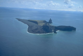
Geological Summary. Bogoslof is the emergent summit of a submarine volcano that lies 40 km N of the main Aleutian arc. It rises 1,500 m above the Bering Sea floor. Repeated construction and destruction of lava domes at different locations during historical time has greatly modified the appearance of this "Jack-in-the-Box" volcano and has introduced a confusing nomenclature applied during frequent visits by exploring expeditions. The present triangular-shaped, 0.75 x 2 km island consists of remnants of lava domes emplaced from 1796 to 1992. Castle Rock (Old Bogoslof) is a steep-sided pinnacle that is a remnant of a spine from the 1796 eruption. The small Fire Island (New Bogoslof), about 600 m NW of Bogoslof Island, is a remnant of a lava dome formed in 1883.
Source: US Geological Survey Alaska Volcano Observatory (AVO)

