Report on Raikoke (Russia) — 19 June-25 June 2019
Smithsonian Institution / US Geological Survey
Weekly Volcanic Activity Report, 19 June-25 June 2019
Managing Editor: Sally Sennert.
Please cite this report as:
Global Volcanism Program, 2019. Report on Raikoke (Russia) (Sennert, S, ed.). Weekly Volcanic Activity Report, 19 June-25 June 2019. Smithsonian Institution and US Geological Survey.
Raikoke
Russia
48.292°N, 153.25°E; summit elev. 551 m
All times are local (unless otherwise noted)
A powerful eruption at Raikoke that began on 22 June (after 95 years of dormancy) was identified based on satellite observations, prompting KVERT and SVERT to raise the Aviation Color Code to Red. A series of at least nine explosions (six within the first 25 minutes) beginning at 0505 and continuing to about 1900 produced ash plumes, with a significant sulfur dioxide component, that rose 10-13 km (32,800-42,700 ft) a.s.l. and drifted E and NE. Lightning was detected in the eruption plumes. Strong explosions at 1640 on 22 June generated ash plumes that rose to 10-11 km (32,800-36,100 ft) a.s.l. The ash and gas was entrained by jet streams and by a cyclone around the Komandorskiye Islands, causing parts of the material to spiral counterclockwise as it drifted farther NE. By 23 June the leading edge of the plume had drifted 2,000 km ENE. According to a news article, at least 40 flights in that region were diverted.
On 23 June ash plumes continued to be visible, rising to 4.5 km and drifting NE. The Aviation Color Code was lowered to Orange. Gas-and-steam plumes possibly with some ash rose to 4.5 km (14,800 ft) a.s.l. and drifted 60 km NW. That same day observers on a passing ship approached the island from the W side; they photographed the island and sent out a drone. An expedition member noted that the entire island was mantled with light-colored ash deposits up to several dozen centimeters thick. In some of the drainages and at the base of some drainages deposits were several meters thick. In some areas along the shoreline waves interacted with the deposits, causing steam explosions and dark brown steam emissions. Gas-and-ash plumes rose 1.5 km above the summit crater rim and drifted W. Minor ashfall was reported in Severo-Kurilsk (340 km NE) during 1830-1920. On 25 June ash plumes continued to be produced, rising as high as 2 km (6,600 ft) a.s.l. and drifting NW.
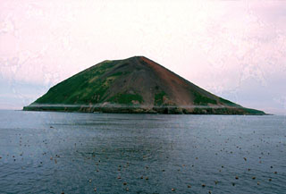
Geological Summary. A low truncated volcano forms the small barren Raikoke Island, which lies 16 km across the Golovnin Strait from Matua Island in the central Kuriles. The oval-shaped basaltic island is only 2 x 2.5 km wide and rises above a submarine terrace. An eruption in 1778, during which the upper third of the island was said to have been destroyed, prompted the first volcanological investigation in the Kuril Islands two years later. Incorrect reports of eruptions in 1777 and 1780 were due to misprints and errors in descriptions of the 1778 event (Gorshkov, 1970). Another powerful eruption in 1924 greatly deepened the crater and changed the outline of the island. Prior to a 2019 eruption, the steep-walled crater, highest on the SE side, was 700 m wide and 200 m deep. Lava flows mantle the eastern side of the island.
Sources: Sakhalin Volcanic Eruption Response Team (SVERT), Kamchatkan Volcanic Eruption Response Team (KVERT), NHK (Japan Broadcasting Corporation)