Report on Kavachi (Solomon Islands) — 29 April-5 May 2020
Smithsonian Institution / US Geological Survey
Weekly Volcanic Activity Report, 29 April-5 May 2020
Managing Editor: Sally Sennert.
Please cite this report as:
Global Volcanism Program, 2020. Report on Kavachi (Solomon Islands) (Sennert, S, ed.). Weekly Volcanic Activity Report, 29 April-5 May 2020. Smithsonian Institution and US Geological Survey.
Kavachi
Solomon Islands
8.991°S, 157.979°E; summit elev. -20 m
All times are local (unless otherwise noted)
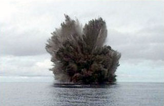
Satellite data showed discolored water around Kavachi beginning on 16 March 2020 extending SE of Kavachi; distinct discolored plumes were also observed on 25 and 30 April 2020. On 25 April a satellite image showed a plume in the water that spread over an approximate area of 30 square kilometers. The image acquired on 30 April showed a thin ribbon of discolored water extending W of Kavachi.
Geological Summary. Named for a sea-god of the Gatokae and Vangunu peoples, Kavachi is located in the Solomon Islands south of Vangunu Island. Sometimes referred to as Rejo te Kvachi ("Kavachi's Oven"), this shallow submarine basaltic-to-andesitic volcano has produced ephemeral islands up to 1 km long many times since its first recorded eruption during 1939. Residents of the nearby islands of Vanguna and Nggatokae (Gatokae) reported "fire on the water" prior to 1939, a possible reference to earlier eruptions. The roughly conical edifice rises from water depths of 1.1-1.2 km on the north and greater depths to the SE. Frequent shallow submarine and occasional subaerial eruptions produce phreatomagmatic explosions that eject steam, ash, and incandescent bombs. On a number of occasions lava flows were observed on the ephemeral islands.
Sources: Sentinel Hub, Culture Volcan