Report on Alu-Dalafilla (Ethiopia) — 19 November-25 November 2008
Smithsonian Institution / US Geological Survey
Weekly Volcanic Activity Report, 19 November-25 November 2008
Managing Editor: Sally Sennert.
Please cite this report as:
Global Volcanism Program, 2008. Report on Alu-Dalafilla (Ethiopia) (Sennert, S, ed.). Weekly Volcanic Activity Report, 19 November-25 November 2008. Smithsonian Institution and US Geological Survey.
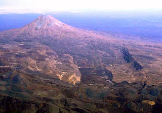
Alu-Dalafilla
Ethiopia
13.793°N, 40.553°E; summit elev. 578 m
All times are local (unless otherwise noted)
During 19-24 November, the MODIS satellite continued to detect thermal anomalies over the area near Dalaffilla and Alu volcanoes from the eruption that began on 3 November.
Geological Summary. The summit region of Alu, ~5 km NW of the Dalafilla stratovolcano, is an ellipsoidal volcanic horst, elongated NNW-SSE, and formed primarily of older basaltic lava flows. Recent fractures along the axis of the Erta Ale range cut the main horst of Alu and areas to the SSE. Fumarolic activity is located on the numerous parallel faults. Fissure vents west of the horst have fed silicic lava flows, and voluminous youthful basaltic lava flows to the east extend north as far as Lake Bakili. Dalafilla, also referred to as Gabuli, is a steep-sided cone that rises 300 m above surrounding lava fields due to extrusion of viscous, silicic lava flows. Basaltic lava flows from regional fissures surround the volcano. Fumarolic activity occurs in the 100-m-wide summit crater and has weathered surrounding lava flows. The first historical eruption of Alu-Dalafilla took place in 2008, when lava flows from vents between the two edifices traveled NE.
Source: Hawai'i Institute of Geophysics and Planetology (HIGP) Thermal Alerts Team