Report on Sakar (Papua New Guinea) — 16 September-22 September 2009
Smithsonian Institution / US Geological Survey
Weekly Volcanic Activity Report, 16 September-22 September 2009
Managing Editor: Sally Sennert.
Please cite this report as:
Global Volcanism Program, 2009. Report on Sakar (Papua New Guinea) (Sennert, S, ed.). Weekly Volcanic Activity Report, 16 September-22 September 2009. Smithsonian Institution and US Geological Survey.
Sakar
Papua New Guinea
5.4098°S, 148.0836°E; summit elev. 947 m
All times are local (unless otherwise noted)
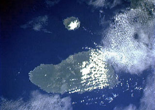
Based on analyses of satellite imagery, the Darwin VAAC reported that on 18 September a possible diffuse ash plume from Sakar rose to an altitude of 1.8 km (6,000 ft) a.s.l. and drifted 165 km NW. Four hours later images showed that the volcano was clear; the plume may have been smoke from a fire or steam. RVO was unable to confirm that an eruption had or had not occurred. [Note: The Darwin VAAC later confirmed that an eruption did not occur.]
Geological Summary. Sakar is an incised stratovolcano with a summit crater lake. Deep valleys cut the flanks of the volcano, which is partially surrounded by coral reefs. An older volcano that forms much of the island consists mainly of porphyritic basaltic rocks. A younger andesitic cone with a 1.5-km-wide crater has been constructed within the larger old crater, whose rim is exposed on the N and E. No eruptions have been reported, but warm springs are found along the SW coast, and a pyroclastic cone on the southern flank of the 8 x 10 km island may be of Holocene age (Johnson, 1990 pers. comm.). A large submarine debris-avalanche deposit lies north of Sakar.