Report on Seulawah Agam (Indonesia) — 1 September-7 September 2010
Smithsonian Institution / US Geological Survey
Weekly Volcanic Activity Report, 1 September-7 September 2010
Managing Editor: Sally Sennert.
Please cite this report as:
Global Volcanism Program, 2010. Report on Seulawah Agam (Indonesia) (Sennert, S, ed.). Weekly Volcanic Activity Report, 1 September-7 September 2010. Smithsonian Institution and US Geological Survey.
Seulawah Agam
Indonesia
5.4472°N, 95.6555°E; summit elev. 1309 m
All times are local (unless otherwise noted)
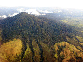
CVGHM reported that although seismicity from Seulawah Agam fluctuated during April to August 2010, the data reflected increased activity overall. On 1 September, CVGHM raised the Alert Level to 2 (on a scale of 1-4) and restricted visitors from approaching the crater within a 3-km radius.
Geological Summary. Seulawah Agam, near the NW tip of Sumatra, is an extensively forested volcano with a small summit crater. It was constructed within the large Pleistocene Lam Teuba caldera, which also contains a smaller 6 x 8 caldera. The van Heutsz crater is an active fumarolic area on the NNE flank extending about 200 m downslope around 700 m elevation; it does not have the appearance of a volcanic crater. Additional geothermal areas are noted by Marwan et al. (2021). Sapper (1927) and Neumann van Padang (1951 CAVW) listed an explosive eruption in the early 16th century, and the CAVW also listed an eruption from the van Heutsz crater in 1839. However, Rock et al. (1982) found no evidence for historical eruptions. The Volcanological Survey of Indonesia also noted that although no reported eruptions have occurred from the main cone, the NNE-flank activity may have only been hydrothermal.
Source: Pusat Vulkanologi dan Mitigasi Bencana Geologi (PVMBG, also known as CVGHM)