
Smithsonian Institution / US Geological Survey
Weekly Volcanic Activity Report, 2 March-8 March 2011
Managing Editor: Sally Sennert
Please cite this report as:
Global Volcanism Program, 2011. Report on Kīlauea (United States) (Sennert, S, ed.). Weekly Volcanic Activity Report, 2 March-8 March 2011. Smithsonian Institution and US Geological Survey. https://volcano.si.edu/showreport.cfm?gvpvar=GVP.WVAR20110302-332010
During 1-4 March, activity from Kīlauea's summit caldera and east rift zone was similar to activity during the previous several weeks. The level of the circulating lava-pool surface in the deep pit within Halemaʻumaʻu crater fluctuated and rose to at most 70 below the crater floor. Scattered surface flows were active on the pali and coastal plain, and lava covered large portions of Puʻu ʻŌʻō's crater floor. An unusually high number of earthquakes were located at Kīlauea; during 1-4 March a majority of the earthquakes were located at the upper east rift zone.
On 5 March at 1342 there was the onset of rapid deflation at Puʻu ʻŌʻō and increased tremor along Kīlauea's middle east rift zone, and at 1400 the summit began to deflate. Between 1416 and 1421 the floor of the Puʻu ʻŌʻō crater began to collapse and within 10 minutes incandescent ring fractures opened on the crater floor. As the floor continued to drop, lava appeared in the center and the NE spatter cone collapsed. The collapse of a large block along the E crater wall produced an ash plume. The floor continued to drop as fume obscured the camera view at 1626. The Aviation Color Code was raised to Red and the Volcano Alert Level was raised to Warning. A later report indicated that the crater floor dropped a minimum of 115 m.
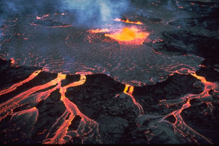
Coincident with the Puʻu ʻŌʻō collapse, an earthquake swarm began along the east rift zone in the area of Maka'opuhi and Napau craters, WSW of Puʻu ʻŌʻō. A fissure, ultimately 2.3 km long, opened along the east rift zone between Napau Crater and Puʻu ʻŌʻō, erupting spatter up to 25 m high and lava that burned nearby vegetation. Lava on one side of the fissure flowed into a nearby deep parallel fissure and disappeared. Fissure activity had paused by 2155.
Kīlauea's summit continued to deflate and the lava lake level within the Halemaʻumaʻu crater vent dropped, facilitating rockfalls from the vent wall. On 6 March at 0703 the lake level to receded almost beyond the webcam view following a large collapse. Spattering from the fissure resumed and two more fissures opened that produced more gas than lava. Spatter was reaching heights of 40 m. The tiltmeter on the N flank of Puʻu ʻŌʻō recorded over 150 microradians of deflation beginning at 1400 on 5 March that markedly slowed by the morning of 6 March. Rockfalls exposed incandescent areas within Puʻu ʻŌʻō. Lava flows on the coastal plain and pali were less active. The average sulfur dioxide emission rate from all east rift zone sources was 10,000 tonnes/day on 6 March, 2011, the highest rate there since an eruptive surge in July 2008 produced an emission rate of 7,000 tonnes/day.
On 7 March the Aviation Color Code was lowered to Orange. Vigorous spattering from the W end of the fissure continued; spatter rose as high as 30 m. No active lava flows were observed on the pali or coastal plain. The lava lake surface in Halemaʻumaʻu crater was 200 m below the crater floor, based on visual estimates. Rockfalls in the crater produced dusty-brown plumes during 7-8 March. Low fountains and spattering from the fissure fed several lava flows that advanced S.
Source: US Geological Survey Hawaiian Volcano Observatory (HVO)
Geological Summary. Kīlauea overlaps the E flank of the massive Mauna Loa shield volcano in the Island of Hawaiʻi. Eruptions are prominent in Polynesian legends; written documentation since 1820 records frequent summit and flank lava flow eruptions interspersed with periods of long-term lava lake activity at Halemaʻumaʻu crater in the summit caldera until 1924. The 3 x 5 km caldera was formed in several stages about 1,500 years ago and during the 18th century; eruptions have also originated from the lengthy East and Southwest rift zones, which extend to the ocean in both directions. About 90% of the surface of the basaltic shield volcano is formed of lava flows less than about 1,100 years old; 70% of the surface is younger than 600 years. The long-term eruption from the East Rift Zone between 1983 and 2018 produced lava flows covering more than 100 km2, destroyed hundreds of houses, and added new coastline.


 Kīlauea