Report on Grimsvotn (Iceland) — 18 May-24 May 2011
Smithsonian Institution / US Geological Survey
Weekly Volcanic Activity Report, 18 May-24 May 2011
Managing Editor: Sally Sennert.
Please cite this report as:
Global Volcanism Program, 2011. Report on Grimsvotn (Iceland) (Sennert, S, ed.). Weekly Volcanic Activity Report, 18 May-24 May 2011. Smithsonian Institution and US Geological Survey.
Grimsvotn
Iceland
64.416°N, 17.316°W; summit elev. 1719 m
All times are local (unless otherwise noted)
According to scientists from the Institute of Earth Sciences at the University of Iceland and the Icelandic Meteorological Office, an eruption from the subglacial Grímsvötn volcano began on 21 May following about an hour of tremor. A GPS-station on the rim of the Grímsvötn caldera had revealed continuous inflation and expansion of few centimeters per year since the 2004 eruption, interpreted as inflow of magma to a shallow chamber. Other precursors over the previous few months were increased seismicity, including some bursts of tremor, and increased geothermal activity.
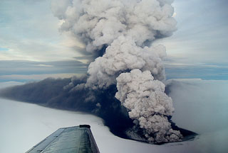
The eruption began at 1630 on 21 May, and at 2000 the eruption plume rose to an altitude over 20 km (65,000 ft) a.s.l. The plume altitude fell to 15 km (49,200 ft) a.s.l. during the night but occasionally still rose to 20 km (65,000 ft) a.s.l. Ash from the lower part of the eruption plume drifted S and at higher altitudes drifted E. A few hours after the onset of the eruption ashfall began over areas S of the Vatnajökull ice cap, more than 50 km from the eruption site. Earthquake locations and limited observations during an initial overflight suggested that the eruption site was in the SW part of the caldera, where the 2004 eruption was located. According to news articles, the road in Skeidarársandur, S of Vatnajökull and part of the ring road around Iceland, closed and remained closed through 24 May.
During the morning of 22 May the plume rose to an altitude of 10-15 km (32,800-49,200 ft) a.s.l. The color of the plume was brown-to-grayish and sometimes black close to the source. Most of the plume drifted S, but lower parts traveled SW. Tephra fall was concentrated to the S and to a lesser extent N and E. In the afternoon lightning strikes ranged from 60-70 per hour (up to 300 during one hour) and were most frequent in the ash plume to the S. News outlets noted that the Keflavík airport closed. Ashfall was reported from the Reykjavík area in the SW to Tröllaskagi Peninsula in the N. An article also stated that, according to a geophysicist, the eruption was the largest for Grímsvötn in 100 years, was similar to the eruption of 1873, and was larger than the Eyjafjallajökull eruption of 2010.
During 22-23 May the ash plume rose to altitudes of 5-10 km (16,400-32,800 ft) a.s.l. and drifted S at lower altitudes and W at altitudes 8 km (26,200 ft) a.s.l. and higher. Ashfall was detected in several areas throughout Iceland except in some areas to the NW. On 24 May the ash plume was estimated to be mostly below 5 km (16,400 ft) a.s.l. because meteorological clouds over the glacier were at 5-7 km (16,400-23,000 ft) a.s.l. and the plume only briefly rose above the cloud deck. Satellite images showed the plume extending over 800 km from the eruption site towards the S and SE. News articles reported that dozens of carriers rerouted or cancelled flights in Norway, Denmark, and Scotland.
Geological Summary. Grímsvötn, Iceland's most frequently active volcano in recent history, lies largely beneath the vast Vatnajökull icecap. The caldera lake is covered by a 200-m-thick ice shelf, and only the southern rim of the 6 x 8 km caldera is exposed. The geothermal area in the caldera causes frequent jökulhlaups (glacier outburst floods) when melting raises the water level high enough to lift its ice dam. Long NE-SW-trending fissure systems extend from the central volcano. The most prominent of these is the noted Laki (Skaftar) fissure, which extends to the SW and produced the world's largest known historical lava flow in 1783. The 15 km3 basaltic Laki lavas were erupted over 7 months from a 27-km-long fissure system. Extensive crop damage and livestock losses caused a severe famine that resulted in the loss of one-fifth of the population of Iceland.
Sources: Icelandic Meteorological Office (IMO), Institute of Earth Sciences, The Local (Sweden), Iceland Review, Associated Press