Report on Tambora (Indonesia) — 7 September-13 September 2011
Smithsonian Institution / US Geological Survey
Weekly Volcanic Activity Report, 7 September-13 September 2011
Managing Editor: Sally Sennert.
Please cite this report as:
Global Volcanism Program, 2011. Report on Tambora (Indonesia) (Sennert, S, ed.). Weekly Volcanic Activity Report, 7 September-13 September 2011. Smithsonian Institution and US Geological Survey.
Tambora
Indonesia
8.25°S, 118°E; summit elev. 2850 m
All times are local (unless otherwise noted)
Based on visual observation and seismic data, CVGHM reported an increase in activity at Tambora that started in April. Therefore, on 30 August, the Alert Level was raised to 2 (on a scale of 1-4). During 30 August-8 September seismicity continued to increase. Diffuse white plumes were observed on 5 September and rose 10 m above the crater rim. On 8 September the Alert Level was raised to 3 (on a scale of 1-4).
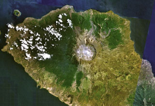
Geological Summary. The massive Tambora stratovolcano forms the entire 60-km-wide Sanggar Peninsula on northern Sumbawa Island. The largely trachybasaltic-to-trachyandesitic volcano grew to about 4,000 m elevation before forming a caldera more than 43,000 years ago. Late-Pleistocene lava flows largely filled the early caldera, after which activity changed to dominantly explosive eruptions during the early Holocene. Tambora was the source of history's largest explosive eruption, in April 1815. Pyroclastic flows reached the sea on all sides of the peninsula, and heavy tephra fall devastated croplands, causing an estimated 60,000 fatalities. The eruption of an estimated more than 150 km3 of tephra formed a 6-km-wide, 1250-m-deep caldera and produced global climatic effects. Minor lava domes and flows have been extruded on the caldera floor at Tambora during the 19th and 20th centuries.
Source: Pusat Vulkanologi dan Mitigasi Bencana Geologi (PVMBG, also known as CVGHM)