Report on Galunggung (Indonesia) — 8 February-14 February 2012
Smithsonian Institution / US Geological Survey
Weekly Volcanic Activity Report, 8 February-14 February 2012
Managing Editor: Sally Sennert.
Please cite this report as:
Global Volcanism Program, 2012. Report on Galunggung (Indonesia) (Sennert, S, ed.). Weekly Volcanic Activity Report, 8 February-14 February 2012. Smithsonian Institution and US Geological Survey.
Galunggung
Indonesia
7.25°S, 108.058°E; summit elev. 2168 m
All times are local (unless otherwise noted)
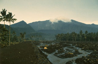
On 13 February, CVGHM reported that from September 2011 to 8 February 2012 discolorations in the crater lake water at Galunggung were observed. In addition, a sudden increase in water temperature was measured, from 27 degrees Celsius on 5 February to 40 degrees on 8 February. Based on seismic data and crater lake observations, CVGHM raised the Alert Level from 1 to 2 (on a scale of 1-4) on 12 February and recommended staying at least 500 m away from the lake shore.
Geological Summary. The forested slopes of Galunggung in western Java SE of Bandung are cut by a 2-km-wide collapse scarp open towards the ESE. The "Ten Thousand Hills of Tasikmalaya" dotting the plain below the volcano are debris-avalanche hummocks from the collapse about 4,200 years ago. An eruption in 1822 produced pyroclastic flows and lahars that killed over 4,000 people. A series of major explosive eruptions starting in April 1982 destroyed a number of villages, killed as many as 30 people, and forced over 60,000 to evacuate. Pyroclastic flows and heavy widespread ash caused significant damage. A large passenger jet that encountered the ash plume on 24 June lost power to all four engines but managed to land safely in Jakarta. The 1982 activity destroyed a 1918 dome and formed the Warirang crater, almost as wide as the valley, about 2 km down from the summit.
Source: Pusat Vulkanologi dan Mitigasi Bencana Geologi (PVMBG, also known as CVGHM)