Report on Semisopochnoi (United States) — 28 July-3 August 2021
Smithsonian Institution / US Geological Survey
Weekly Volcanic Activity Report, 28 July-3 August 2021
Managing Editor: Sally Sennert.
Please cite this report as:
Global Volcanism Program, 2021. Report on Semisopochnoi (United States) (Sennert, S, ed.). Weekly Volcanic Activity Report, 28 July-3 August 2021. Smithsonian Institution and US Geological Survey.
Semisopochnoi
United States
51.93°N, 179.58°E; summit elev. 1221 m
All times are local (unless otherwise noted)
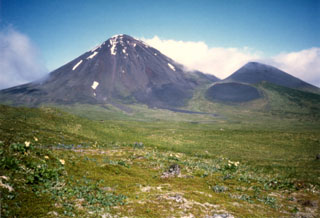
AVO reported that seismicity at Semisopochnoi had increased in recent days. A notable increase at 0200 on 31 July prompted AVO to raise the Aviation Color Code to Orange and the Volcano Alert Level to Watch a few hours later. Additionally, increased infrasound recorded by local stations suggested low-level emissions. Weather clouds obscured satellite views, though a possible sulfur dioxide plume was detected. Steaming was visible in webcam images. Increased seismicity and elevated activity in infrasound data were recorded during 31 July-1 August, and multiple, discrete, energetic explosions were detected during 1-3 August. Weather clouds again obscured satellite views; steaming was visible in webcam views. Beginning at 1015 on 2 August the local networks recorded an explosion and an intense burst of seismic and acoustic tremor that lasted for about 15 minutes. A small ash cloud was visible in satellite images drifting 60 km N at altitudes of 1.5-3 km (5,000-10,000 ft) a.s.l. Ash emissions from the active vent in North Crater were visible in webcam views on the morning of 3 August.
Geological Summary. Semisopochnoi, the largest subaerial volcano of the western Aleutians, is 20 km wide at sea level and contains an 8-km-wide caldera. It formed as a result of collapse of a low-angle, dominantly basaltic volcano following the eruption of a large volume of dacitic pumice. The high point of the island is Anvil Peak, a double-peaked late-Pleistocene cone that forms much of the island's northern part. The three-peaked Mount Cerberus (renamed Mount Young in 2023) was constructed within the caldera during the Holocene. Each of the peaks contains a summit crater; lava flows on the N flank appear younger than those on the south side. Other post-caldera volcanoes include the symmetrical Sugarloaf Peak SSE of the caldera and Lakeshore Cone, a small cinder cone at the edge of Fenner Lake in the NE part of the caldera. Most documented eruptions have originated from Young, although Coats (1950) considered that both Sugarloaf and Lakeshore Cone could have been recently active.
Source: US Geological Survey Alaska Volcano Observatory (AVO)