Report on Bulusan (Philippines) — 8 June-14 June 2022
Smithsonian Institution / US Geological Survey
Weekly Volcanic Activity Report, 8 June-14 June 2022
Managing Editor: Sally Sennert.
Please cite this report as:
Global Volcanism Program, 2022. Report on Bulusan (Philippines) (Sennert, S, ed.). Weekly Volcanic Activity Report, 8 June-14 June 2022. Smithsonian Institution and US Geological Survey.
Bulusan
Philippines
12.769°N, 124.056°E; summit elev. 1535 m
All times are local (unless otherwise noted)
PHIVOLCS reported that increased seismicity at Bulusan began at 0500 on 9 June, characterized by a total of 45 volcanic earthquakes, including two low-frequency events. Most of the events were low magnitude and shallow. A phreatic eruption was detected at 0337 on 12 June. Plumes were not visible in webcam images due to darkness, but residents of Inlagadian (Casiguran municipality) briefly saw incandescence at the base of a plume. In data from seismic and infrasound instruments the event was classified as an explosion-type earthquake which lasted about 18 minutes. An explosion was felt by residents within 5 km, including in the barangays of Añog (Juban) and Inlagadian. Rumbling was heard in Sitio Bagong Barrio, and in barangays of Santa Lourdes (Barcelona), Inlagadian and San Juan (Casiguran), Bentuco (Gubat), and Añog, Calateo, and Puting Sapa (Juban). Sporadic ash emissions began to be observed at 0430. At daybreak emissions were visible rising from six vents: Blackbird Crater (the main crater), three explosion pits in the summit crater, and two vents on the NW and N sides of the summit. Steam, gas, and ash plumes rose 400-750 m above the summit and drifted several kilometers NW. Ash carried by winds fell in areas as far as 50 km NW, in Sorsogon City and Palanas, Pilar, Sorsogon Province, across Sorsogon Bay, and as far as Anislag, Daraga, Albay. Ash on the upper NW flanks was visible, and several barangays in the municipalities of Casiguran, Juban, and Magallanes experienced minor ashfall. Emissions continued throughout the day. According to a news article more than 11,000 people (at least 2,800 families) in Juban evacuated, and flights in and out of the Bicol International Airport were cancelled. The Alert Level remained at 1 (on a scale of 0-5) and PHIVOLCS reminded the public not to enter the 4-km-radius Permanent Danger Zone (PDZ) nor the 2 km Extended Danger Zone (EDZ) on the SE flank. After the eruption gas emissions rose from the main crater and, for the first time this year, from the NW summit vent.
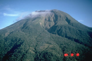
Geological Summary. Luzon's southernmost volcano, Bulusan, was constructed along the rim of the 11-km-diameter dacitic-to-rhyolitic Irosin caldera, which was formed about 36,000 years ago. It lies at the SE end of the Bicol volcanic arc occupying the peninsula of the same name that forms the elongated SE tip of Luzon. A broad, flat moat is located below the topographically prominent SW rim of Irosin caldera; the NE rim is buried by the andesitic complex. Bulusan is flanked by several other large intracaldera lava domes and cones, including the prominent Mount Jormajan lava dome on the SW flank and Sharp Peak to the NE. The summit is unvegetated and contains a 300-m-wide, 50-m-deep crater. Three small craters are located on the SE flank. Many moderate explosive eruptions have been recorded since the mid-19th century.
Sources: Philippine Institute of Volcanology and Seismology (PHIVOLCS), Rappler

