Report on Katmai (United States) — 29 June-5 July 2022
Smithsonian Institution / US Geological Survey
Weekly Volcanic Activity Report, 29 June-5 July 2022
Managing Editor: Sally Sennert.
Please cite this report as:
Global Volcanism Program, 2022. Report on Katmai (United States) (Sennert, S, ed.). Weekly Volcanic Activity Report, 29 June-5 July 2022. Smithsonian Institution and US Geological Survey.
Katmai
United States
58.279°N, 154.9533°W; summit elev. 2047 m
All times are local (unless otherwise noted)
AVO reported that on 30 June strong winds in the vicinity of Katmai and the Valley of Ten Thousand Smokes blew unconsolidated ash NW at an altitude up to 1.8 km (6,000 ft) a.s.l. The ash was originally deposited during the Novarupta eruption in 1912. The Volcano Alert Level remained at Normal and the Aviation Color Code remained at Green.
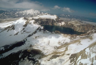
Geological Summary. Katmai was initially considered to be the source of the Valley of Ten Thousand Smokes ash flow in 1912. However, the 3 x 4 km caldera of 1912 is now known to have formed as a result of the voluminous eruption at nearby Novarupta volcano. The edifice had four NE-SW-trending summits, most of which were truncated by the 1912 collapse. Two or more large explosive eruptions took place during the late Pleistocene. Most of the two overlapping pre-1912 Katmai volcanoes are Pleistocene, but Holocene lava flows from a flank vent descend the SE flank of the SW edifice into the Katmai River canyon. The steep walled young caldera has a jagged rim that rises 500-1,000 m above the caldera floor and contains a deep lake. Lake waters have covered a small post-collapse lava dome (Horseshoe Island) that was seen on the caldera floor at the time of the initial ascent to the caldera rim in 1916.
Source: US Geological Survey Alaska Volcano Observatory (AVO)