Keyword Collections | Keyword "black smoker"
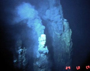 These black smoker vents are located along the Cleft Segment, the southernmost segment of the Juan de Fuca Ridge. These sustained high-temperature vents were photographed along fissures that fed an older lava flow adjacent to a 1986 lava flow that was erupted during the second of two documented submarine eruptions in the 1980s. The 80-km-long Cleft Segment is located immediately north of the Blanco Fracture Zone about 500 km off the Oregon coast.
Image courtesy of National Oceanic and Atmospheric Administration (http://www.pmel.noaa.gov/vents/home.html).
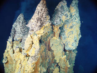 Active smoker chimneys precipitating iron, copper and zinc sulfides from 230°C fluid are found at the Black Forest hydrothermal area within the submarine caldera of East Diamante volcano. They are 9 m tall from the base to the top. The submarine volcano contains an elongated NE-SW-trending caldera with a pronounced rim on the NE side. A complex of lava domes constructed in the center of the caldera is the site of several hydrothermal areas.
Image courtesy of Submarine Ring of Fire 2004 Exploration, NOAA Vents Program.
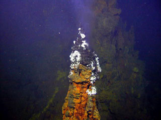 Submarine hydrothermal activity occurs at Brothers volcano, as seen here at this tall (up to 4 m high), active black smoker chimney, which is part of a large field of vents on the NW caldera wall. The oval-shaped caldera is 3-3.5 km wide and contains a post-caldera lava dome constructed on the S caldera floor.
Image courtesy of New Zealand-American Submarine Ring of Fire 2005 Exploration, NOAA Vents Program.
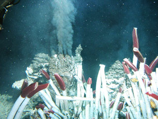 Fluid containing precipitates rises from a "black smoker" chimney at the Tica vent at 9°N on the East Pacific Rise, photographed during a 2004 expedition sponsored by the National Science Foundation. Hot-vent animal communities (such as seen in the foreground of this image from the November to December 1989 expedition) were observed to have been buried by lava flows in 1991. Another eruption in 2005-2006 produced lava flows that covered seismometers.
Photo courtesy of Ridge2000, 2004 (http://www.ridge2000.org/eo/expeditions.php).
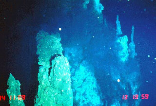 Black smoker hydrothermal vents emitting high-chlorinity fluids were photographed at the "RM29" site at 18°10’S. This image was taken in November 1994 from the Japanese submersible Shinkai 6500. The axial crest of Segment J of the Southern East Pacific Rise consists of an asymmetrical shallow graben varying from 250 to 600 m wide with walls about 20 m high.
Image courtesy of NOAA Vents Program, 1994 (www.pmel.noaa.gov/vents/chemistry/images/).
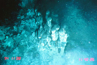 Black smoker vents emitting low-chlorinity fluids at 374°C were photographed at the "RM28" site at 18°26’S on Segment I of the Southern East Pacific Rise in November 1994 from the Japanese submersible Shinkai 6500. The narrow axial crest of Segment I of the Southern East Pacific Rise in some places is less than 50 m wide. The largest lava flow field in this area is the Animal Farm flow, named after a thriving low-temperature hydrothermal site discovered during a 1993 submersible expedition.
Image courtesy of NOAA Vents Program, 1994 (www.pmel.noaa.gov/vents/chemistry/images/).
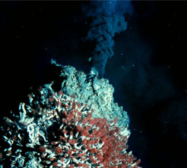 This 360°C black smoker chimney is located in the Endeavour Ridge segment of the Main Endeavour hydrothermal field at the northern end of the Juan de Fuca Ridge. Tube worms with red gills thrive on the edifice, which is predominantly composed of iron- and sulfur-bearing minerals. The 90-km-long ridge segment, which lies west of the coast of Washington and SW of Vancouver Island, is the site of vigorous high-temperature hydrothermal vent systems that were first discovered by scientists in 1981.
Image courtesy of NOAA Ocean Explorer and University of Washington.


