Global Volcanism Program | Image GVP-03664
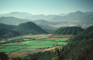
The summit ridge of flat-topped Volcán Molcajete (left) is at the level of the horizon in this view from the SW. Molcajete, referring to stone bowls used for grinding grains, is a common name applied to scoria cones with well-preserved craters. Volcán El Tecomate is the steep-sided scoria cone to the right. These two cones are located NE of the town of Mascota and are part of a Pleistocene-to-Holocene volcanic field in the Jalisco block, which is being underthrust by the eastward-subducting Rivera tectonic plate.
Photo by Jim Luhr, 1985 (Smithsonian Institution).
![]() This image is made available under the Public Domain Dedication CC0 license, but proper attribution is appreciated.
This image is made available under the Public Domain Dedication CC0 license, but proper attribution is appreciated.
Keywords: volcanic field | scoria cone
Mascota Volcanic Field