Image GVP-07651

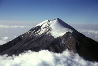
Like other volcanoes in the Cofre de Perote-Pico de Orizaba chain, Orizaba was constructed on the edge of the Altiplano and consequently has higher relief on the eastern side facing the Atlantic coastal plain. Glaciated Orizaba towers 4,200 m above fields near the town of Coscomatepec on its eastern flank. The valley to the left was impacted by the voluminous clay-rich Tetelzingo debris avalanche and lahar during the late Pleistocene.
Photo by Lee Siebert, 1998 (Smithsonian Institution).
![]() This image is made available under the Public Domain Dedication CC0 license, but proper attribution is appreciated.
This image is made available under the Public Domain Dedication CC0 license, but proper attribution is appreciated.
Keywords: stratovolcano
Pico de Orizaba