Image GVP-07764

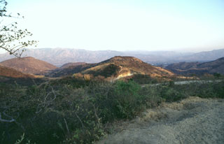
The Chiquimula volcanic field occupies a fault-bounded basin in the Chiquimula Valley of SE Guatemala. Recent eruptions produced basaltic scoria cones and lava flows constructed along a N-S-trending fracture starting near the northern edge of Chiquimula town. Part of the town is seen on the valley floor to the right of the hill in the center of this photo, taken from the NW along the road to Maraxco.
Photo by Giuseppina Kysar, 1999 (Smithsonian Institution).
![]() This image is made available under the Creative Commons BY-NC-ND 4.0 license terms.
This image is made available under the Creative Commons BY-NC-ND 4.0 license terms.
Keywords: scoria cone
Chiquimula Volcanic Field