Image GVP-10216

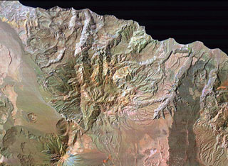
El Aguajito caldera is located along the Gulf of California immediately NE of Tres Vírgenes volcano (lower left) and NW of La Reforma caldera (partially visible at the right). The approximately 10-km-wide caldera covers the broad dissected area from Tres Vírgenes to the sea. The rim of the mid-Pleistocene caldera is not exposed, but an arcuate line of andesitic-to-rhyolitic lava domes lies along its northern margin. Hot springs are located along the southern caldera margin in the linear NW-trending valley between the caldera and Tres Vírgenes.
NASA Landsat image (processed by Brian Hausback, UC Sacramento).
![]() This image is made available under the Creative Commons BY-NC 4.0 license terms.
This image is made available under the Creative Commons BY-NC 4.0 license terms.
San Ignacio Volcanic Field