Image GVP-10292

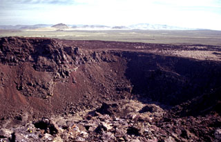
One of a series of interlocking craters forming the complex summit of Black Butte, the vent of the Shoshone lava field, is seen here from the summit of the butte. The broad, low Shoshone shield volcano fed voluminous lava flows that traveled a small distance north towards the Mount Bennett Hills in the background, but the bulk of the flows traveled initially south and then west for a total distance of 60 km. The Shoshone lava field, erupted about 10,000 years ago, is the westernmost of the young volcanic fields of the Snake River Plain.
Photo by Lee Siebert, 2002 (Smithsonian Institution).
![]() This image is made available under the Public Domain Dedication CC0 license, but proper attribution is appreciated.
This image is made available under the Public Domain Dedication CC0 license, but proper attribution is appreciated.
Black Butte Crater Lava Field