Image GVP-10442

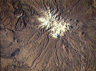
Sahand volcano (Kuh-e-Sahand) is located in NW Iran, about 60 km E of Lake Urmia and 40 km SSE of the city of Tabriz. The city of Maragheh (darker area at bottom left) lies below the S flanks of the volcano. Numerous lava domes (upper right) occupy the lower flanks of the volcano.
NASA Space Shuttle image STS74-708-25, 1995 (http://eol.jsc.nasa.gov/).
![]() This image is made available as a Public Domain Work, but proper attribution is appreciated.
This image is made available as a Public Domain Work, but proper attribution is appreciated.
Keywords: remote sensing
Sahand