Global Volcanism Program | Image GVP-10786

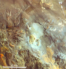
The circular light-colored area in the center of this Thematic Mapper image is the 6-km-wide Robledo caldera. The Cerro Blanco del Robledo rhyolitic lava dome on the southern rim of the caldera was extruded into a pumice cone (pale tones). The margins of pyroclastic flows erupted prior to extrusion of the lava dome are faintly visible on the caldera floor and on the NW flanks of the caldera. Satellite geodetic surveys in the central Andes showed subsidence of Robledo caldera in the 1990s.
Thematic Mapper image (de Silva and Francis, 1991; courtesy of Matthew Pritchard, California Institute of Technology).
![]() This image is made available under the Creative Commons BY-NC 4.0 license terms.
This image is made available under the Creative Commons BY-NC 4.0 license terms.
Cerro Blanco