Image GVP-11124

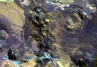
The irregular 10-km-long N-S-trending chain just left of the center of this Landsat image is Cerros de Guayaques. These rhyodacitic lava domes straddle the Chile-Bolivia border. The 10-km-long chain is located immediately east of the Purico pyroclastic shield, part of which is visible on the left side of the image. A well-defined summit crater was the source of the largest lava flows, which form the lobate flows that extend 3 km to the SW. There are no records of historical activity from Guayaques volcano.
NASA Landsat image, 1999 (courtesy of Hawaii Synergy Project, Univ. of Hawaii Institute of Geophysics & Planetology).
![]() This image is made available as a Public Domain Work, but proper attribution is appreciated.
This image is made available as a Public Domain Work, but proper attribution is appreciated.
Guayaques