Global Volcanism Program | Image GVP-11157

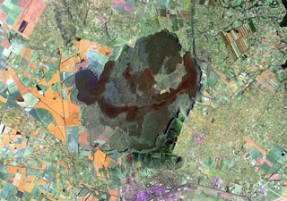
Farmlands occupy the flanks of Menengai shield volcano on the floor of the East African Rift. A major explosive eruption about 8,000 years ago resulted in formation of the 12 x 8 km wide caldera seen in this Landsat image. More than 70 post-caldera lava flows cover the caldera floor, the youngest of which may be only a few hundred years old. Most lava flows erupted from vents near the center of the caldera and ponded against the caldera walls. The city of Nakuru lies at the bottom of the image, south of the caldera.
NASA Landsat image, 1999 (courtesy of Hawaii Synergy Project, Univ. of Hawaii Institute of Geophysics & Planetology).
![]() This image is made available as a Public Domain Work, but proper attribution is appreciated.
This image is made available as a Public Domain Work, but proper attribution is appreciated.
Keywords: remote sensing | lava flow
Menengai