Global Volcanism Program | Image GVP-11166

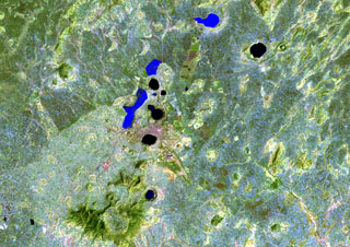
The Bishoftu volcanic field is a chain of lake-filled maars (dark-colored in this Landsat image), tuff cones, and scoria cones, lies along the Ethiopian Rift Valley. The city of Debre Zeit (left-center) lies between two maars, the irregular-shaped Lake Hora and the circular Lake Bishoftu. The Haro Maja tuff ring and its neighbor to the west, lake-filled Kilole maar (upper right), are offset to the east.
NASA Landsat image, 1999 (courtesy of Hawaii Synergy Project, Univ. of Hawaii Institute of Geophysics & Planetology).
![]() This image is made available as a Public Domain Work, but proper attribution is appreciated.
This image is made available as a Public Domain Work, but proper attribution is appreciated.
Galleries: Volcanic Fields | Maars
Keywords: remote sensing | maar | tuff cone | volcanic field
Bishoftu Volcanic Field