Global Volcanism Program | Image GVP-11183

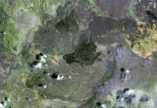
Dabbayra (center), the westernmost volcano of the Afar depression, lies near the edge of the Ethiopian escarpment. In contrast to structural trends in other parts of Afar, Dabbayra (also known as Bar-Ali) consists of a basaltic shield volcano elongated in an ENE-WSW direction. The only silicic volcanic rocks are a NNW-trending line of lava domes and lava flows near the crest of the volcano
NASA Landsat image, 1999 (courtesy of Hawaii Synergy Project, Univ. of Hawaii Institute of Geophysics & Planetology).
![]() This image is made available as a Public Domain Work, but proper attribution is appreciated.
This image is made available as a Public Domain Work, but proper attribution is appreciated.
Keywords: remote sensing | lava flow | shield volcano
Dabbayra