Global Volcanism Program | Image GVP-11469

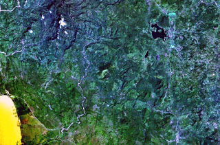
The small circular volcano at the center of this NASA Landsat image east (right) of the Río Pacora (left of center) is Cerro el Ciguatepe. This volcano lies in the Nicaraguan interior highlands, east of yellow-colored Lake Managua (lower left). A prominent breach can be seen in the SW wall of the well-preserved 1.5-km-wide crater. A small lava flow extends a short distance beyond the base of the cone through the breach, and a blocky plug dome was emplaced in the center of the crater. The dark-colored lake at the upper right is Laguna Moyua.
NASA Landsat 7 image (worldwind.arc.nasa.gov)
![]() This image is made available as a Public Domain Work, but proper attribution is appreciated.
This image is made available as a Public Domain Work, but proper attribution is appreciated.
Cerro el Ciguatepe