Global Volcanism Program | Image GVP-11509

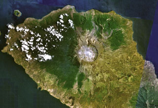
Tambora volcano on Indonesia's Sumbawa Island produced of the world's largest historical eruption in April 1815. This NASA Landsat mosaic shows the 6-km-wide caldera at the top of the 2,850-m-high summit. Pyroclastic flows during the 1815 eruption reached the sea on all sides of the 60-km-wide volcanic peninsula, and the ejection of large amounts of volcanic gas (aerosols) caused world-wide temperature declines in 1815 and 1816.
NASA Landsat 7 image (worldwind.arc.nasa.gov)
![]() This image is made available as a Public Domain Work, but proper attribution is appreciated.
This image is made available as a Public Domain Work, but proper attribution is appreciated.
Keywords: caldera
Tambora