Image GVP-11523

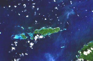
A cluster of basaltic volcanoes forms the Mundua Islands, N of New Britain. The largest volcanic center is formed by the western tip of the 7-km-wide Mundua Island and the arcuate Wingoru Island immediately to the west. The crater is flooded by the sea through narrow channels on the N and S sides. Small cones can be seen on the E side of Mundua. The W tip of Garove Island is visible at the lower right in this NASA Landsat image.
NASA Landsat 7 image (worldwind.arc.nasa.gov)
![]() This image is made available as a Public Domain Work, but proper attribution is appreciated.
This image is made available as a Public Domain Work, but proper attribution is appreciated.
Mundua