Global Volcanism Program | Image GVP-11926

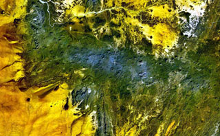
The dark-green and bluish-gray areas extending across this NASA Landsat false-color image depict the elongated, E-W-trending Tahalra volcanic field, which covers an area of about 1,800 km2 in the Hoggar Province of southern Algeria. About 100 small basaltic cones formed during the Pliocene and Pleistocene, and the most recent activity during the late-Pleistocene and Holocene, produced about 20 maars and cones along the northern margin of the volcanic field.
NASA Landsat 7 image (worldwind.arc.nasa.gov)
![]() This image is made available as a Public Domain Work, but proper attribution is appreciated.
This image is made available as a Public Domain Work, but proper attribution is appreciated.
Galleries: Volcanic Fields
Keywords: remote sensing | volcanic field
Tahalra Volcanic Field