Image GVP-12002

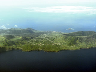
The south of Graciosa island is seen in this aerial view from the southwest. The village of Luz is at the center of the image. On the right (the southeast end of the island), is the 0.9 x 1.5 km Vulcão Central caldera, which formed between 60,000 and 11,000 years ago; the caldera rim forms the highest point of the 7 x 12 km island. The lava cave Furna Do Enzofre is situated in the southeastern part of the caldera, and exhibits fumarolic activity. Vegetated volcanic cones and part of the approximately 700,000 year old Serra das Fontes complex can be seen in the left of the photo.
Photo by Angrense, 2007 (Wikimedia Commons).
![]() This image is made available under the Creative Commons BY-NC 4.0 license terms.
This image is made available under the Creative Commons BY-NC 4.0 license terms.
Graciosa