Image GVP-12037

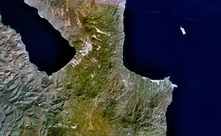
The lower of the two small peninsulas at the lower right is Punta Púlpito, a Pleistocene obsidian dome dated at about 0.5 million years. The dome juts into the Gulf of California (right) in this NASA Landsat image with north to the top and lies east of the southern end of Bahía Concepción (upper left). The Saquicismunde geothermal area lies near the dome, and the larger Los Volcanes geothermal area, which lies along the coast about 5 km south of Punta el Púlpito, contains 18 fumaroles.
NASA Landsat 7 image (worldwind.arc.nasa.gov)
![]() This image is made available as a Public Domain Work, but proper attribution is appreciated.
This image is made available as a Public Domain Work, but proper attribution is appreciated.
Punta Púlpito