Global Volcanism Program | Image GVP-12318

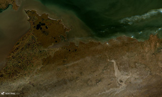
The St. Michael volcanic field consists of more than 55 cones and craters across Stuart Island (upper left) and the peninsula in the center of this 18 August 2020 Sentinel-2 satellite image (N is at the top; this image is approximately 40 km across). The field covers more than 3,000 km2. The Stuart Hill cone is visible in the eastern side of Stuart island, and St. Michael Mountain is in the center of the peninsula area.
Satellite image courtesy of Copernicus Sentinel Data, 2019.
![]() This image is made available under the Creative Commons BY-SA 4.0 license terms.
This image is made available under the Creative Commons BY-SA 4.0 license terms.
Keywords: volcanic field
St. Michael