Global Volcanism Program | Image GVP-12597

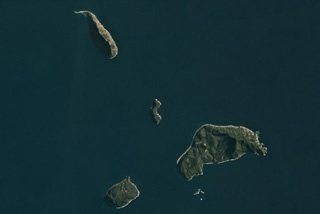
The NE Shepherd Islands group is south of Tongoa Island in Vanuatu and is shown in this 10 August 2020 PlanetScope satellite image (N is at the top). The islands are the northernmost, 2.8-km-long Ewose, Falea in the center, Tongariki to the SE, and Buninga to the SW. The islands contain outcrops of lava flows, pyroclastic deposits, and dikes.
Satellite image courtesy of Planet Labs Inc., 2020 (https://www.planet.com/).
Copyrighted image used with permission. All Rights Reserved. Contact photographer for any usage requests.
Northeast Shepherd Islands