Report on Tupungatito (Chile-Argentina) — April 1988
Bulletin of the Global Volcanism Network, vol. 13, no. 4 (April 1988)
Managing Editor: Lindsay McClelland.
Tupungatito (Chile-Argentina) Fatal 29 November debris flow not related to volcanism
Please cite this report as:
Global Volcanism Program, 1988. Report on Tupungatito (Chile-Argentina) (McClelland, L., ed.). Bulletin of the Global Volcanism Network, 13:4. Smithsonian Institution. https://doi.org/10.5479/si.GVP.BGVN198804-357010
Tupungatito
Chile-Argentina
33.425°S, 69.797°W; summit elev. 5660 m
All times are local (unless otherwise noted)
The event started as a rockfall of ~3-4 x 10⁶ m3 of lower Cretaceous sedimentary rocks and gypsum on the eastern slope of the Estero (stream) del Parraguirre, 20 km NW of Tupungatito and separated from it by at least four high ridges of Mesozoic rocks (figure 1). The rockfall mass developed into a mudflow after reaching the bottom of the stream valley and moved into the Río Colorado, causing casualties and destroying roads, bridges, camps, and the Los Maitenes hydroelectric power plant. Geologists noted that the rockfall appeared to have been triggered by a combination of geologic and hydrologic factors: steep walls, highly fractured rocks, water influx, and the presence of gypsum and other salts.
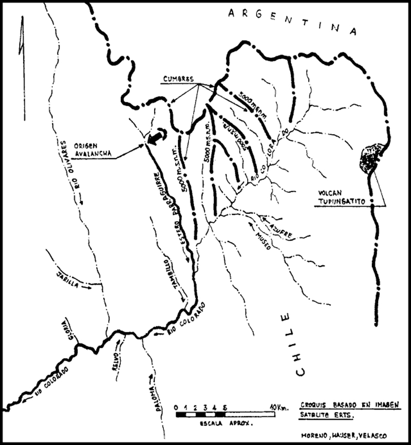 |
Figure 1. Sketch map by Hugo Moreno R., Arturo Hauser Y., and Lucio Velasco V., based on ERTS satellite data. The source of the rockfall in the headwaters of the Estero del Parraguirre is indicated by an arrow and its path down that stream and the Río Colorado is shown by a bold line. Positions of ridges between the source of the rockfall and Tupungatito Volcano are marked by heavy dash-dot lines; their approximate elevations are designated. |
Geological Summary. Tupungatito volcano, the northernmost historically active volcano of the central Chilean Andes, is located along the Chile-Argentina border about 90 km E of Santiago and immediately SW of the Pleistocene Tupungato volcano. Tupungatito consists of a group of 12 Holocene andesitic and basaltic andesite craters and a pyroclastic cone at the NW end of the 4-km-wide, Pleistocene dacitic Nevado Sin Nombre caldera, which is filled by glaciers at its southern end and is breached to the NW. Lava flows from the northernmost vent have traveled down the NW flank breach. Tupungatito has produced frequent mild explosive eruptions during the 19th and 20th centuries.
Information Contacts: L.Velasco Villegas, Compañía Chilena de Generación Eléctrica, Santiago; A. Yung, SERNAGEOMIN, Santiago; H. Moreno, Univ de Chile.