Report on Tupungatito (Chile-Argentina) — June 1988
Bulletin of the Global Volcanism Network, vol. 13, no. 6 (June 1988)
Managing Editor: Lindsay McClelland.
Tupungatito (Chile-Argentina) Volcanic seismicity may have triggered November debris flow
Please cite this report as:
Global Volcanism Program, 1988. Report on Tupungatito (Chile-Argentina) (McClelland, L., ed.). Bulletin of the Global Volcanism Network, 13:6. Smithsonian Institution. https://doi.org/10.5479/si.GVP.BGVN198806-357010
Tupungatito
Chile-Argentina
33.425°S, 69.797°W; summit elev. 5660 m
All times are local (unless otherwise noted)
O. González-Ferrán presented additional information about the cause and dynamics of the 29 November 1987 debris flow.
"Tupungatito volcano has been increasing its thermal activity since January 1986 and on 28, 29, and 30 November 1987 registered an increase in local shallow seismic activity. Seismographs of the Chilean and Argentine nets registered some B-type shocks. The seismicity caused 15 rockfalls of different magnitudes within 5-20 km of the historically active craters . . . (N and NW of the ice-filled summit caldera) during that period (figure 2).
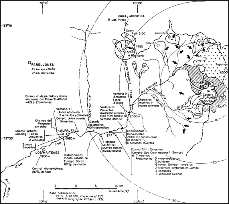 |
Figure 2. Sketch map illustrating the 15 rockfalls documented near Tupungatito in late November (heavy arrows), and tabulating the casualties and damage caused by the 29 November debris flow. Courtesy of O. González-Ferrán. |
"One of the shocks occurred at 103340 on the 29th, causing one of the rockfalls, which reached a volume of 17.25 x 10⁶ m3 in the headwaters of the Estero Parraguirre, 17 km from the active crater and the epicentral zone of the seismic activity.
"A mass of sedimentary rocks from the headwaters of the Estero Parraguirre free-fell 1100 m onto the terminal front of a glacier, impacting it with a velocity of ~300 km/hour. Incorporated in the impact was 1.2 x 10⁶ m3 of ice, as well as 11 x 106 m3 of snow along the Estero.
"This generated the avalanche debris flow that discharged into the Río Colorado, temporarily obstructing the flow of the Colorado's waters. Finally, the debris flow reached the Central Hidroeléctrica de Maitenes at 1114 with a velocity of 50-60 km/hour, causing the death of 41 persons and millions of dollars in losses to buildings and machinery along its path. In addition, by damaging the Las Vizcachas plant, it affected the supply of drinking water to nine communes of the city of Santiago (population 4.5 million) for 24 hours.
"The high instability and strong fracturing of the nearly vertical strata of Mesozoic sedimentary rocks in this mountainous region of the Tupungatito area, along with the supersaturation and water pressure generated by snowmelt and the abnormal seasonal temperature increase, facilitated rockfalls and avalanches as a consequence of the local volcano-seismic activity of Tupungatito."
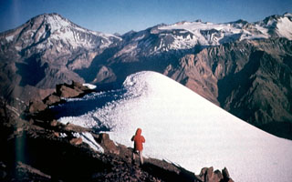
Geological Summary. Tupungatito volcano, the northernmost historically active volcano of the central Chilean Andes, is located along the Chile-Argentina border about 90 km E of Santiago and immediately SW of the Pleistocene Tupungato volcano. Tupungatito consists of a group of 12 Holocene andesitic and basaltic andesite craters and a pyroclastic cone at the NW end of the 4-km-wide, Pleistocene dacitic Nevado Sin Nombre caldera, which is filled by glaciers at its southern end and is breached to the NW. Lava flows from the northernmost vent have traveled down the NW flank breach. Tupungatito has produced frequent mild explosive eruptions during the 19th and 20th centuries.
Information Contacts: O. Gonzalez-Ferrán, Univ de Chile; J. Castrano, Instituto Nacional de Prevención Sísmica, San Juan, Argentina; S. Kunstmann, Empresa Nacional de Electricidad, Santiago; G. Ugarte, Pontificia Univ Católica de Chile, Santiago.