Report on Dawson Strait Group (Papua New Guinea) — January 1990
Bulletin of the Global Volcanism Network, vol. 15, no. 1 (January 1990)
Managing Editor: Lindsay McClelland.
Dawson Strait Group (Papua New Guinea) Felt swarm of A- and B-type earthquakes; divers film submarine vents and hear booming and roaring
Please cite this report as:
Global Volcanism Program, 1990. Report on Dawson Strait Group (Papua New Guinea) (McClelland, L., ed.). Bulletin of the Global Volcanism Network, 15:1. Smithsonian Institution. https://doi.org/10.5479/si.GVP.BGVN199001-253060
Dawson Strait Group
Papua New Guinea
9.62°S, 150.88°E; summit elev. 500 m
All times are local (unless otherwise noted)
"A swarm of earthquakes took place in the Esa'Ala area in mid-December 1989. Earthquakes were felt with intensities MM III-V by villagers at Esa'Ala, Dobu Island, and on SE Fergusson Island at Oiau, Deidei, and Numa Numa. The local volcano observatory at Esa'Ala noted felt events on the 10th (26 events), 11th (12), 12th (6), and the 13th (3).
"Reports received at RVO on 11 and 13 December prompted a 5-day on-site inspection and local seismic recording by three RVO officers, 13-18 December. When local recording resumed at Esa'Ala Volcano Observatory (on the 13th), 30 sharp volcano-tectonic earthquakes (A-type with S-P
Table 1. Number of A- and B-type events recorded at the Esa 'Ala Observatory, 13-17 December 1989.
| Date | A-type | B-type |
| 13 Dec 1989 | 30 | 57 |
| 14 Dec 1989 | 25 | 55 |
| 15 Dec 1989 | 23 | 27 |
| 16 Dec 1989 | 12 | 16 |
| 17 Dec 1989 | 16 | 9 |
"The deployment of two portable seismographs at Numa Numa and Waiope Island, together with the seismograph at the Esa'Ala Volcano Observatory, allowed location of some of the larger earthquakes. Of the five earthquakes located, three occurred in the Dobu passage, another under Dobu Island, and the 5th between Dobu Island and Neumara Island (figure 1). These locations lie [near the outline] of an inferred submerged caldera.
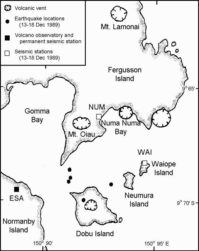 |
Figure 1. Map of the Dawson Strait Group area, showing volcanic vents, the volcano observatory (with permanent seismograph), sites of two portable seismographs deployed 13-18 December 1989, and the five earthquakes located during that period. Courtesy of RVO. |
"The strongest earthquake caused minor landslides from 4-30-m cliffs of pyroclastic deposits along the N and E shores of Dobu Island, and one landslide inland, from a steep gulley on the E flank of Dobu. Ground cracks, 1-4 m inland and 0.5-2 cm wide, reported at Kenaie village on the NE side of Dobu Island were related to the collapse of marine cliffs parallel to their edges.
"Off the N coast of Dobu Island on the afternoon of the 11th, a team of professional divers filmed and photographed very turbulent springs (28°C) and degassing vents through sand holes up to 1 m in diameter, at a depth of 6 m of water. They also reported subcontinuous booming and roaring underwater sounds (at an estimated 30-40 db level).
"The December 1989 earthquake swarm was the first episode of unrest [in this area] since April 1969. At that time (1969), over a period of a few days, 5-7 shocks were felt daily, accompanied by noises. This prompted spontaneous evacuation of villagers on Dobu Island and around Oiau Volcano. Recording at the time was from one station only (ESA). On the basis of the S-P interval (1-1.4 seconds) and reports of earthquake intensities, the swarm was presumed to have originated from the Dobu Passage."
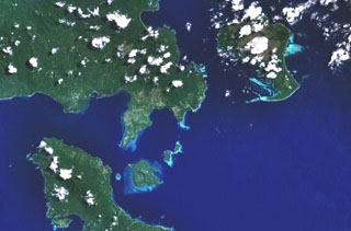
Geological Summary. The Dawson Straits, located between eastern Fergusson and western Normanby Islands in the D'Entrecasteaux island group, contains a volcanic field with several centers that define a possible partly submerged caldera. There have been no historical eruptions, but morphology suggests an extremely young age for some lava flows, and the area displays vigorous thermal activity. The most prominent volcanic centers are Mounts Lamonai and Oiau, located about 10 km apart on the SW tip of Fergusson Island. The summit of Lamonai is capped by a steep-walled crater, and rhyolitic lava flows are exposed on the NE side of the cone. The dominantly volcaniclastic Oiau cone has also produced obsidian lava flows. Dobu Island to the south is formed of coalescing volcanic centers and likewise has produced youthful rhyolitic obsidian flows.
Information Contacts: I. Itikarai and P. de Saint-Ours, RVO.