Report on Redoubt (United States) — March 1990
Bulletin of the Global Volcanism Network, vol. 15, no. 3 (March 1990)
Managing Editor: Lindsay McClelland.
Redoubt (United States) Moderate explosions and dome extrusion; rootless phreatic explosion as eruptions interact with glaciers
Please cite this report as:
Global Volcanism Program, 1990. Report on Redoubt (United States) (McClelland, L., ed.). Bulletin of the Global Volcanism Network, 15:3. Smithsonian Institution. https://doi.org/10.5479/si.GVP.BGVN199003-313030
Redoubt
United States
60.485°N, 152.742°W; summit elev. 3108 m
All times are local (unless otherwise noted)
Quoted material is from the AVO staff. Information about the 4, 9, and 14 March explosive episodes supplements the initial reports in 15:02.
"Lava dome growth disrupted by moderate explosions and gravitational collapse continued. Since 15 February, explosive episodes have occurred at average intervals of 3-9 days (table 1). Explosive episodes were associated with pyroclastic flows and surges that triggered floods and lahars in the Drift River valley, which drains the volcano's N flank (figure 8). Seismicity remained centered on Redoubt from the surface to a depth of about 10 km, but earthquakes of M >= 2.0 have not occurred since 9 March. The summit seismometer that was damaged during the 15 February event was removed in March and three new seismometers were placed on the volcano's summit and flanks. COSPEC measurements began on 20 March; data are collected as weather permits. SO2 emission rates have ranged from 1,600 to 6,000 t/d."
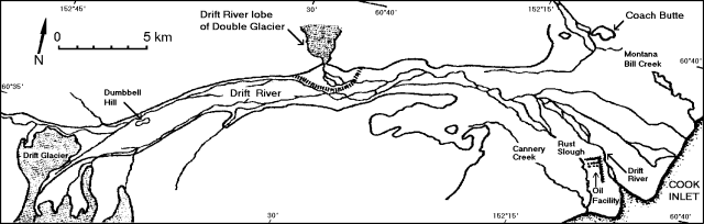 |
Figure 8. Sketch map of the Drift River valley and related drainages on the NE flank of Redoubt. The Drift River oil facility is between the mouth of the Drift River and Rust Slough. Courtesy of AVO. |
Since early January, deposition in the Drift River's main channel has diverted significant amounts of flood water and debris into Rust Slough, S of the Drift River oil facility. An L-shaped 4-m-high levee upstream from the oil facility was designed to protect it from Drift River floods, but neither levees nor topography protect its S side. Beginning on 4 March, deposition in Rust Slough has diverted floodwater farther southward into Cannery Creek, just upstream of the Drift River facility. None of the subsequent floods associated with March-mid April explosive episodes have affected the oil facility.
Explosive episode, 4 March. "An explosive event that occurred at 2039 was recorded for 8 minutes at the Spurr station (a regional seismometer about 100 km NNE of Redoubt that has been operating since the onset of the eruption). By 2110, an ash plume was reported to an altitude of 12 km; the plume moved N20°E and ashfall occurred 225 km away. Moderate flooding occurred in the Drift River. A new diversion upstream of the Drift River oil facility caused much of the flow to be diverted S of the facility (from Rust Slough into Cannery Creek).
Explosive episode, 9 March. "An explosive event occurred at 0951 and was recorded for 10 minutes at the Spurr station. Tephra fell primarily W of the volcano; Port Alsworth, 95 km SW of the volcano, received a light dusting from the southern margin of the plume. Floodwater reached the Drift River oil facility about 2 3/4 hours after the onset of the event.
Explosive episode, 14 March. "Explosive activity that began at 0947 was recorded for 14 minutes at the Spurr station. Tephra fell E of the volcano; the Drift River oil facility reported heavy ashfall from 1057 to 1247. Oil facility crews were evacuated because of the heavy ashfall. Traces of ash were reported on the Kenai Peninsula and in the Anchorage area." Satellite images (figure 9) showed the plume moving ENE. The temperature at the top of the dense portion of the plume was -40°C at 1030, corresponding to an altitude of about 7 km. Winds were relatively light, and by 1230, the plume extended less than 150 km N and about 100 km E of the volcano.
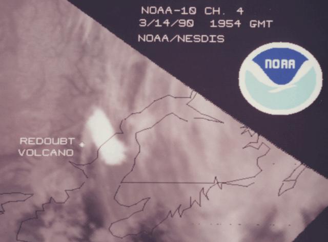 |
Figure 9. Image from the NOAA 10 polar orbiting satellite, 14 March at 1054, about an hour after the onset of the eruptive episode. An elongate plume extends ENE of Redoubt. Courtesy of G. Stephens. |
"Moderate flooding occurred in the lower Drift River valley. Peak flow velocity was about 6 m/sec. The flood reached the oil facility about 2 1/4 hours after the onset of the explosive episode. The flood carried numerous ice blocks and hot angular dome rocks 16 km from the glacier, where peak discharge was estimated at 1200 m3/sec.
"On 15 March, after a vigorous 2.5-minute seismic event was recorded at all seismic stations, an AVO field crew was warned about a possible explosion. They reported no changes in steam plume activity and did not hear any noises. However, 20 minutes later, they noted an approximate doubling of the Drift River's discharge 4 km downstream from the glacier. The increased discharge was accompanied by large quantities of cobble-sized ice.
"A small dome in the summit area was observed by field crews on 16, 18, 20, and 21 March. The dome appeared to be growing slowly between observations.
Explosive episode, 23 March. "Seismicity indicating the onset of explosive activity began at 0404 and was recorded for 8 minutes at the Spurr station. Seismic activity at the summit stations had increased around 0000 on 22 March and had stayed at elevated levels for most of the day. Seismic activity then decreased several hours before the 23 March explosive episode. A plume was reported to 10.5 km but appeared to be mostly steam. Light ashfall was observed W of the mountain, but ash did not fall on any community. Discharge increased in the Drift River."
An image from the NOAA 11 polar orbiting satellite at 0430 (figure 10), 26 minutes after the onset of the explosive episode, showed a plume extending WNW from the volcano. The top of the dense portion of the plume had a temperature of -39°C, yielding an altitude estimate of slightly less than 9 km based on the radiosonde temperature/altitude profile over Anchorage 1.5 hours earlier. The plume continued to move rapidly WNW, and by 1430, 10.5 hours after the explosion, its center was about 850 km from the volcano.
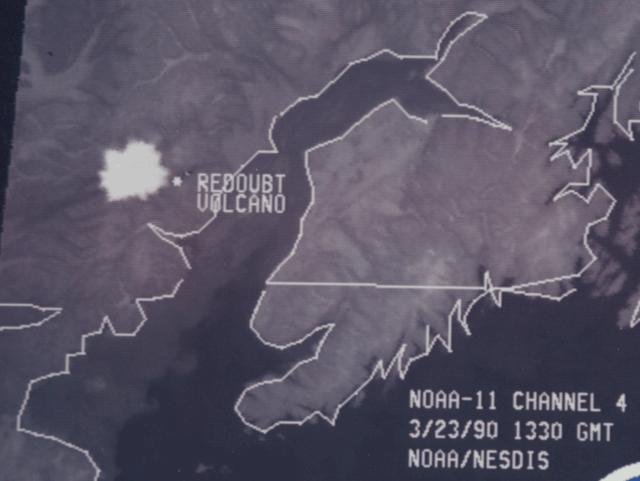 |
Figure 10. Image from the NOAA 11 polar orbiting satellite, 23 March at 0430, about 30 minutes after the start of the eruptive episode. The nearly circular plume is just WNW of Redoubt. Courtesy of G. Stephens. |
"Pyroclastic flow deposits covered the lower Canyon (below 825 m) and the upper piedmont area (above 500 m) of the Drift glacier. The deposits were generally hot, dry, and friable; where they rested on snow, the basal part of thick deposits, and those less than 50 cm thick, were wet and warm to the touch. Pyroclastic deposits were still hot (325°C) when measured on 26 March.
"Views into the crater on 23 March were largely obscured by steam but much of the dome appeared missing from the summit area. Poor weather obscured observations of the summit area from 26 March until 6 April.
Explosive episode, 29 March. "Seismic activity indicated that an explosive event began at 1033 and was recorded for 7 minutes at the Spurr station. An increase in discharge of the Drift River was reported, reaching the oil facility by 1307. Pilots reported a plume, consisting chiefly of steam, to 15 km. Tephra fallout appears to have been similar to that of 4 March; light ashfall was reported to 225 km N-NE of the volcano.
"Poor weather prevented ground observations or views of the glacier. Deposits from a debris flow or hyperconcentrated flow were observed in the upper valley and flooding appeared similar to 23 March. No hot debris or ice blocks were observed in the upper valley.
Explosive episode, 6 April. "Seismicity increased throughout the morning of 6 April. An explosive event began at 1723 and was recorded for 7-8 minutes at the Spurr station. Seismicity declined after the explosive event. An ash plume was reported to 9 km; wind shear caused the lower part of the plume to drift NW and the upper part to drift E. The ash plume reached the W coast of the Kenai Peninsula by 1808, but only light ashfall was reported in Kenai during the evening.
"Pyroclastic flow deposits overlay the glacier down to about the 610 m level. A debris flow of dome-rock material and ice boulders flowed onto the Drift River valley, and peak flow velocity was estimated at 22 m/s. Peak discharge attenuated quickly downvalley.
Dome growth and hydrologic events 7-13 April. "A dome was first observed in the summit area on 7 April. This dome appeared to be larger when observed on 10 and 13 April and was greatly oversteepened on the N face.
"On 7 April, discharge near the E canyon mouth of the Drift River glacier fluctuated by 30-50% several times during a 1/2-hour observation period. A flood of ice blocks up to 1 m across caused a 4-fold discharge increase in one of the large glacier canyons. Repeated increases in discharge were noted over a 15-minute observation period. An iceslide blocked the entire width of the canyon bottom upstream of the increased discharge area. Episodic release through a tunnel at the base of the ice jam may explain the surges observed at the canyon mouth.
"On 10 April a rootless phreatic eruption was noted on the Drift Glacier at the 890 m level, causing a vigorous ash and steam plume to rise 1,000 m. A series of explosions migrated N and S of this area along a glacier bed stream, producing an elongate crater perhaps 300 m long. Numerous small pyroclastic flows emanated from the explosion area and formed a small pyroclastic flow fan that dammed the main water flow from the dome area for about an hour. Failure of the dam caused a flood with an estimated discharge of 10 m3/s.
Explosive event, 15 April. "A moderate explosive event occurred at 1440 and lasted about 8 minutes at the Spurr station. The ash plume reached elevations between 9 and 12 km and the plume moved N-NW. There were no clearly identifiable seismic precursors. Seismic activity before and after the event appeared unchanged." [See also 15:04].
Geological Summary. Redoubt is a glacier-covered stratovolcano with a breached summit crater in Lake Clark National Park about 170 km SW of Anchorage. Next to Mount Spurr, Redoubt has been the most active Holocene volcano in the upper Cook Inlet. The volcano was constructed beginning about 890,000 years ago over Mesozoic granitic rocks of the Alaska-Aleutian Range batholith. Collapse of the summit 13,000-10,500 years ago produced a major debris avalanche that reached Cook Inlet. Holocene activity has included the emplacement of a large debris avalanche and clay-rich lahars that dammed Lake Crescent on the south side and reached Cook Inlet about 3,500 years ago. Eruptions during the past few centuries have affected only the Drift River drainage on the north. Historical eruptions have originated from a vent at the north end of the 1.8-km-wide breached summit crater. The 1989-90 eruption had severe economic impact on the Cook Inlet region and affected air traffic far beyond the volcano.
Information Contacts: AVO Staff; SAB.