Report on Kilauea (United States) — March 1990

Bulletin of the Global Volcanism Network, vol. 15, no. 3 (March 1990)
Managing Editor: Lindsay McClelland.
Kilauea (United States) Eruption stops briefly then resumes after seismic swarm; lava destroys house
Please cite this report as:
Global Volcanism Program, 1990. Report on Kilauea (United States) (McClelland, L., ed.). Bulletin of the Global Volcanism Network, 15:3. Smithsonian Institution. https://doi.org/10.5479/si.GVP.BGVN199003-332010
Kilauea
United States
19.421°N, 155.287°W; summit elev. 1222 m
All times are local (unless otherwise noted)
Lava flows . . . remained active during the first half of March. The main (Quarry) and low-volume (Roberts) flows continued to enter the ocean, while a third (Keone) flow advanced slowly to within 600 m of a highway at 30 m elevation (figure 66). Activity was periodically observed at Pu`u `O`o. Crusted lava in Kupaianaha pond averaged 30 m below the rim and only overturned a few times/day, in contrast to vigorous past activity. On the 19th, the eruption stopped and the lava pond roofed over. Small collapse pits were found in the lava pond's crust the next day. Only residual lava from the Quarry and Roberts lava tubes drained into the ocean on the 21st.
Activity resumed on the night of the 21st, with glow reported from the East rift zone. By the next day, active lava was visible in Pu`u `O`o, had risen to 20 m below the rim at Kupaianaha, and had reoccupied the tube system to 550 m elevation. Surface lava breakouts at 550 and 600 m elevation fed two flows. Lava followed the course of the January 1990 flow between the December 1986 and 1977 aa flows, and by the end of the month had reached 200 m elevation. Lava also followed the course of the Keone flow, to within 500 m of the intersection of highways 130 and 137. Kupaianaha pond remained active through 23 March when it again began to roof over ~30 m below the rim, and by the 26th, only small pahoehoe lobes were periodically active around the pond's margins.
Seismic signals . . . marked the eruption's changes. From early to mid-March, sporadic gas pistoning was recorded, manifested as background volcanic tremor decreasing to an essentially quiet state for several minutes, generally ending with a sharp burst of energy followed by continued background tremor. This activity subsided after 17 March, succeeded by a marked increase in tremor and, on the afternoon of 18 March, brief summit deflation.
At Kīlauea's summit, swarms of long-period tremor events occurred from late 16 March through midday 18 March and from the evening of 19 March through the early morning of the 21st (figure 67). A swarm of short-period microearthquakes began later that morning and continued until early 22 March. Five hours after the onset of the summit swarm, and several hours before eruptive activity resumed, a sudden increase in earthquakes occurred in the upper East rift zone between the summit and the active craters. The hypocenters were in two areas: near Makaopuhi (roughly midway between the summit caldera rim and Kupaianaha) and Pauahi (~5 km uprift from Makaopuhi). The swarm continued until the morning of 25 March.
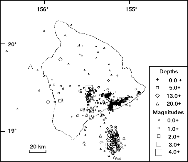 |
Figure 67. Preliminary locations of earthquakes in the Hawaii Island region, including Kīlauea and Lōʻihi, 1-26 March 1990. Courtesy of R. Koyanagi. |
After lava returned to Kupaianaha on 22 March, variations in seismicity became less obvious. Tremor near Pu`u `O`o increased gradually and was relatively steady from the 24th until the end of the month.
Addendum: Eruptive activity declined on 5 April [see also 15:4], but had resumed by the night of the 6th. Lava entered Kalapana Gardens subdivision on 3 April, and within three weeks had destroyed a dozen houses.
Geological Summary. Kilauea overlaps the E flank of the massive Mauna Loa shield volcano in the island of Hawaii. Eruptions are prominent in Polynesian legends; written documentation since 1820 records frequent summit and flank lava flow eruptions interspersed with periods of long-term lava lake activity at Halemaumau crater in the summit caldera until 1924. The 3 x 5 km caldera was formed in several stages about 1,500 years ago and during the 18th century; eruptions have also originated from the lengthy East and Southwest rift zones, which extend to the ocean in both directions. About 90% of the surface of the basaltic shield volcano is formed of lava flows less than about 1,100 years old; 70% of the surface is younger than 600 years. The long-term eruption from the East rift zone between 1983 and 2018 produced lava flows covering more than 100 km2, destroyed hundreds of houses, and added new coastline.
Information Contacts: C. Heliker, P. Okubo, and R. Koyanagi, HVO; AP.