Report on Waesche (Antarctica) — March 1990
Bulletin of the Global Volcanism Network, vol. 15, no. 3 (March 1990)
Managing Editor: Lindsay McClelland.
Waesche (Antarctica) No signs of recent activity
Please cite this report as:
Global Volcanism Program, 1990. Report on Waesche (Antarctica) (McClelland, L., ed.). Bulletin of the Global Volcanism Network, 15:3. Smithsonian Institution. https://doi.org/10.5479/si.GVP.BGVN199003-390024
Waesche
Antarctica
77.17°S, 126.88°W; summit elev. 3292 m
All times are local (unless otherwise noted)
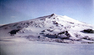
January 1990 fieldwork revealed no fumarolic ice towers or other signs of recent activity. A thick (<=4 m) sequence of tephra was found in blue ice at the foot of the volcano, but its vertical attitude suggested eruptions thousands of years ago.
Geological Summary. Mount Waesche is the southernmost of a N-S chain of volcanoes in central Marie Byrd Land, 20 km SW of Pliocene Mount Sidley. The Waesche shield was constructed around 1.0 Ma on the SE rim of the 10-km-wide Chang Peak caldera; pre-caldera Chang Peak lavas were erupted about 1.6 Ma. Satellitic cinder cones, some aligned along radial fissures, are located on the SW flank. The youngest dated products suggest a pulse of effusive activity between about 200,000 and 100,000 years ago.
Information Contacts: P. Kyle and W. McIntosh, New Mexico Institute of Mining and Technology; R. Dibble, Victoria Univ.