Report on Kilauea (United States) — April 1990

Bulletin of the Global Volcanism Network, vol. 15, no. 4 (April 1990)
Managing Editor: Lindsay McClelland.
Kilauea (United States) E Rift lava flows destroy dozens of homes
Please cite this report as:
Global Volcanism Program, 1990. Report on Kilauea (United States) (McClelland, L., ed.). Bulletin of the Global Volcanism Network, 15:4. Smithsonian Institution. https://doi.org/10.5479/si.GVP.BGVN199004-332010
Kilauea
United States
19.421°N, 155.287°W; summit elev. 1222 m
All times are local (unless otherwise noted)
. . . lava production continued from Kupaianaha vent, feeding flows that overran dozens of houses in a community near the coast. Lava production halted briefly in early April and early May but promptly resumed each time, and activity remained vigorous in mid-May. Shallow tremor . . . continued at a low level.
Lava that had advanced to just above [Hwy 130] by the end of March crossed the highway on 2 April (100 m E of its intersection with Highway 137). A small N-facing fault scarp (the Hakuma horst) blocked the flow's direct path to the sea, turning it ESE toward Kalapana Gardens subdivision, in a low-lying area below the scarp (figure 68). Lava entered the subdivision's W edge on 3 April, destroying two houses the next morning, but lava production stopped late that day. Tremor amplitude near Kupaianaha decreased appreciably 4-6 April while lava production was stopped. As in previous instances, USGS geologists believe that the pause in lava production was due to blockage in the upper East rift zone. The summit responded with a sequence of deflation and shallow tremor followed by inflation and an increased number of shallow microearthquakes. Eruptive activity resumed during the night of 6-7 April. By the time of an early morning overflight, lava had reoccupied the tube system along the E side of the flow field, and numerous breakouts were occurring along much of its length, between ~600 and 120 m (1,950 and 400 ft) altitude. The lava formed three flows, the largest advancing along roughly the same path as previous flows toward Hwy 130.
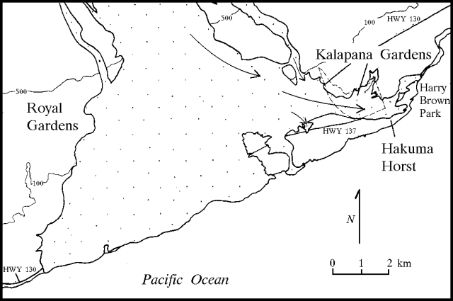 |
Figure 68. Kalapana Gardens and the E side of Royal Gardens subdivision on Kīlauea's S flank, April 1990. |
The primary flow moved down the main flow field to ~120 m (400 ft) elevation, then turned E, following approximately the same path as the previous Kalapana Gardens flow. The lava advanced slowly, but by 13 April two separate lobes had crossed Highway 130, one on top of the early April flow along the Hakuma horst, the other farther E. The W lobe entered Kalapana Gardens on 17 April. The two lobes merged by the 20th. Two homes just outside Kalapana Gardens were destroyed on 13 and 15 April, and destruction of houses within the subdivision began on 18 April. By the end of the month, the April flows had overrun nearly 4 dozen houses, had cut off the main access road into the subdivision (Highway 137) and were moving along both Highway 137 and the fault scarp below it. By 3 May, the flows reached Kalapana village, an older settlement to the E. As of 5 May, the Hawaii County Civil Defense Agency reported that the eruption had destroyed 63 houses since 4 April.
A smaller flow, originating from the breakout at ~600 m elevation, moved diagonally toward the E side of the lava field . . . into the "woodchip area," then onto the December 1986 flow. Lava in this area advanced slowly through April, reaching 30 m (100 ft.) elevation by the end of the month. Another small flow originated from a breakout high in the tube system at slightly above 600 m (2,050 ft) elevation, cutting across lava from Kupaianaha vent and advancing W onto earlier aa lava from Pu`u `O`o . . . . This flow entered the extreme NE corner of Royal Gardens subdivision by mid-April, but moved down the E edge of the subdivision without threatening any homes, reaching ~250 m (800 ft) elevation by the end of the month.
When lava production halted briefly on 7 May [see also 15:3], two lobes had reached the water. One partially filled a spring-fed brackish water inlet behind the fault scarp, and the second (W) lobe reached the open ocean (at Harry K. Brown Park) E of Kalapana Gardens. Lava production resumed during the evening of 9 May. Onset of the renewed activity was gradual, but the eruption was again vigorous by the 11th. On 14 May, lava traveling over roughly the same route as previous flows had reached 120 m (400 ft) elevation and was again turning E toward Kalapana Gardens.
Kupaianaha vent . . . generally remained covered with frozen lava at ~18 m below the rim throughout April, having effectively become part of the tube system. After lava production resumed on 9 May, lava in the pond was at times again actively overturning. Lava also returned to the bottom of Pu`u `O`o after 9 May, but dimensions were difficult to estimate at the base of the 180-m-deep crater.
April seismicity generally conformed to the pattern of crustal earthquakes that has persisted beneath Kīlauea and the SE part of Mauna Loa. Small (M <2.0) shallow (<5 km) events were mainly centered beneath Kīlauea's summit and East rift zone. Of the hundreds of earthquakes processed in April, eight ranged from magnitude 3.0 to 4.4.
Geological Summary. Kilauea overlaps the E flank of the massive Mauna Loa shield volcano in the island of Hawaii. Eruptions are prominent in Polynesian legends; written documentation since 1820 records frequent summit and flank lava flow eruptions interspersed with periods of long-term lava lake activity at Halemaumau crater in the summit caldera until 1924. The 3 x 5 km caldera was formed in several stages about 1,500 years ago and during the 18th century; eruptions have also originated from the lengthy East and Southwest rift zones, which extend to the ocean in both directions. About 90% of the surface of the basaltic shield volcano is formed of lava flows less than about 1,100 years old; 70% of the surface is younger than 600 years. The long-term eruption from the East rift zone between 1983 and 2018 produced lava flows covering more than 100 km2, destroyed hundreds of houses, and added new coastline.
Information Contacts: C. Heliker, P. Okubo, and R. Koyanagi, HVO; AP.