Report on Lascar (Chile) — April 1990

Bulletin of the Global Volcanism Network, vol. 15, no. 4 (April 1990)
Managing Editor: Lindsay McClelland.
Lascar (Chile) 1989 dome continues to sag along arcuate fissures; small tephra emission; tremor but no discrete earthquakes
Please cite this report as:
Global Volcanism Program, 1990. Report on Lascar (Chile) (McClelland, L., ed.). Bulletin of the Global Volcanism Network, 15:4. Smithsonian Institution. https://doi.org/10.5479/si.GVP.BGVN199004-355100
Lascar
Chile
23.37°S, 67.73°W; summit elev. 5592 m
All times are local (unless otherwise noted)
Field observations suggest that the dome extrusion . . . has stopped since at least November and that the dome has continued to collapse above a withdrawing, degassing, magma column, accompanied by small, mainly phreatomagmatic eruptions.
During a summit climb by C. Oppenheimer on 4 April, little activity was seen on the collapsed dome region during daylight. Almost all of the visibly fuming vents were located beyond its margins, particularly on the E side where several powerful fumaroles were active (figure 6). After dark, very few if any of those vents were seen to be incandescent. The collapsed dome, however, showed numerous glowing red patches, presumed to be high-temperature fumarolic vents concentrated along ring fractures (figure 7). Individual vents were probably <0.5-1 m across; the majority appeared to be only a few centimeters across but formed clusters along roughly arcuate trends close to the edge of the collapsed dome. A broad area in the dome's center had no incandescent sites. There were a few groups of incandescent fumarolic vents beyond the collapsed dome, at locations that seemed to correspond spatially to distinct hot pixels on Landsat TM images of October-December 1989 (processed at Open Univ).
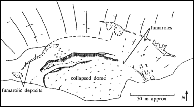 |
Figure 6. Lascar's active crater in daylight, 4 April 1990, showing locations of strong fumaroles. Sketch by C. Oppenheimer. |
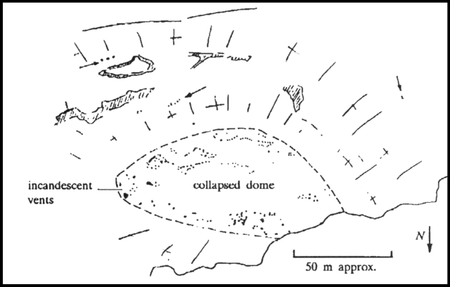 |
Figure 7. Lascar's active crater at night, 4 April 1990. Dark spots on the collapsed dome and crater walls represent incandescent areas. Note that north is down, the opposite orientation to figure 6. Sketch by C. Oppenheimer. |
The highest brightness temperature, measured over a vent close to the E margin of the collapsed dome (by an 0.8-1.1 mm infrared thermometer) was 787°C. The glowing region filled about 1/6 of the instrument's field of view; the temperature measured around the incandescent vent was ~540°C. Oppenheimer noted that use of the Planck function suggests an actual temperature of the glowing vent, and therefore the gas, of ~940°C.
A seismometer (Portable Kinemetrics MEQ-800) installed 17 km W of the volcano (in the village of Talabre) began recording local seismic activity on 4 April. The seismic station was established by Juan Thomas (Antofagasta Branch, Dept de Geofísica, Univ de Chile) who also trained the village teacher, Manuel Castillo, in its operation. A second seismometer, installed the next day 7.5 km from the volcano (at Tumbre), had to be retired 2 days later because of logistics and operation problems. Installation was supported by Nelson Allendes and data interpreted by Sergio Barrientos (both with the Dept de Geología y Geofísica, Univ de Chile, Santiago).
Seismograms 4-19 April indicated that Lascar's seismicity was limited to tremor every 2-3 minutes, interpreted as magma movements in a chamber of unknown depth. Geologists suggested that the absence of discrete earthquakes could indicate that there was no rupturing of material adjusting to pressure from ascending magma. Installation of the Talabre seismometer is scheduled to end in late May. However, strong recommendations were made to local authorities that permanent monitoring of Lascar be established with telemetrically controlled seismometers, given its distance from any research center or large city (270 km from Antofagasta and 1,200 km from Santiago).
A small eruptive episode was observed on 6 April at 0840 from Talabre and by MINSAL geologists in Toconao. A pale grayish cloud rose to ~1,000 m above the volcano in 1-2 minutes. No sounds were audible during the activity, which appeared to be phreatomagmatic. The seismometers at Talabre and Tumbre recorded no seismicity at the time of the eruptive episode. During the following 20 minutes, the plume was dispersed to the SE, rapidly turning white. Some ash could be seen falling from its base. By 0910, the plume was indistinguishable from weather clouds and the normal vapor plume had reappeared, rising to ~300 m above the crater rim. The vapor plume was weaker than normal 7-8 April, reaching <100 m above the rim, but had strengthened to the usual 900 m height by the 9th.
An ascent of the volcano's S side by Steve Matthews on 12 April showed the dome to be essentially unchanged, with continuing strong fumarolic activity. Fresh tension cracks just outside the N margin of the dome, produced by further collapse, were photographed. Geologists interpreted the eruptive episode as the result of a dome collapse event, given the tension cracking and lack of associated seismicity.
Geological Summary. Láscar is the most active volcano of the northern Chilean Andes. The andesitic-to-dacitic stratovolcano contains six overlapping summit craters. Prominent lava flows descend its NW flanks. An older, higher stratovolcano 5 km E, Volcán Aguas Calientes, displays a well-developed summit crater and a probable Holocene lava flow near its summit (de Silva and Francis, 1991). Láscar consists of two major edifices; activity began at the eastern volcano and then shifted to the western cone. The largest eruption took place about 26,500 years ago, and following the eruption of the Tumbres scoria flow about 9000 years ago, activity shifted back to the eastern edifice, where three overlapping craters were formed. Frequent small-to-moderate explosive eruptions have been recorded since the mid-19th century, along with periodic larger eruptions that produced ashfall hundreds of kilometers away. The largest historical eruption took place in 1993, producing pyroclastic flows to 8.5 km NW of the summit and ashfall in Buenos Aires.
Information Contacts: M. Gardeweg, SERNAGEOMIN, Santiago; S. Barrientos, Univ de Chile, Santiago; J. Thomas, Proyecto Sismológico Antofagasta; S. Matthews, Univ College London; C. Oppenheimer, Open Univ.