Report on Lonquimay (Chile) — April 1990
Bulletin of the Global Volcanism Network, vol. 15, no. 4 (April 1990)
Managing Editor: Lindsay McClelland.
Lonquimay (Chile) Isopach maps of December 1988-January 1990 eruption
Please cite this report as:
Global Volcanism Program, 1990. Report on Lonquimay (Chile) (McClelland, L., ed.). Bulletin of the Global Volcanism Network, 15:4. Smithsonian Institution. https://doi.org/10.5479/si.GVP.BGVN199004-357100
Lonquimay
Chile
38.379°S, 71.586°W; summit elev. 2832 m
All times are local (unless otherwise noted)
"A final cumulative ashfall isopach map was made after the Navidad cone eruption, which ended by 23-25 January 1990. The 3 February 1989 preliminary map (see figure 6) was based on 67 data points. After the eruption ended, 40 were checked, but only 19 sites were considered valid. All were located in open spaces within the forest, on flat surfaces and with some grass; therefore, wind or water action has been minimized, although some variation could have been caused by minor ash removal from leaves through wind action. Values increased by 3-19 times the 3 February 1989 measurements.
"Ash thicknesses at six sites previously sampled in February had increased 3- to 4-fold when measured again by 25 September 1989. Consequently rejected were all new measurements <3x those of February, and those that were meaningless in the context of the 19 chosen values. Among them, nine had <70% of the February value x 3, and were located in open windy areas (in the Colorado and Lonquimay valleys). The other 12 sites had more than the February value x 3 and were located in the Naranjo River valley and the E slope of the Cordillera Las Raíces (figure 17). Undoubtedly, the main ash removal agent has been the wind. Water action was observed on slopes less than 20°, and big volumes of ash had been carried down the Cautín and Naranjo headwaters, burying trees, bushes, and wire fences."
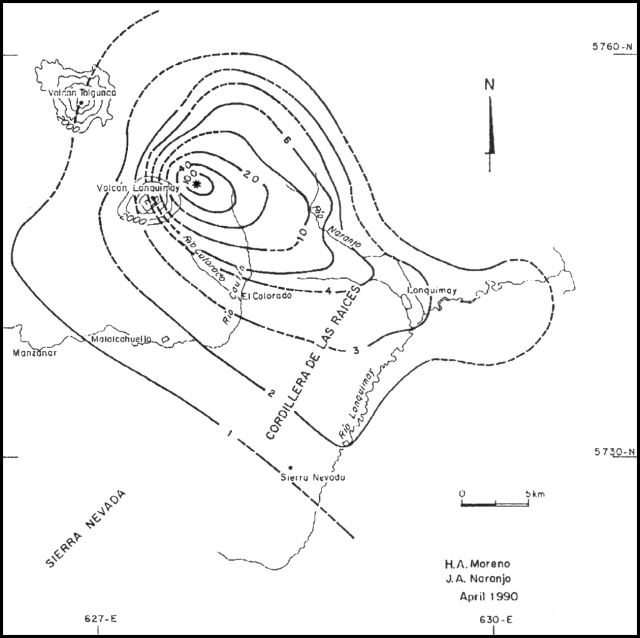 |
Figure 17. Final ash isopach map (in centimeters) after the full 13 months of the Lonquimay eruption. Courtesy of H. Moreno and J. Naranjo. |
Geological Summary. Lonquimay is a small, flat-topped, symmetrical stratovolcano of late-Pleistocene to dominantly Holocene age immediately SE of Tolguaca volcano. A glacier fills its summit crater and flows down the S flank. It is dominantly andesitic, but basalt and dacite are also found. The prominent NE-SW Cordón Fissural Oriental fissure zone cuts across the entire volcano. A series of NE-flank vents and scoria cones were built along an E-W fissure, some of which have been the source of voluminous lava flows, including those during 1887-90 and 1988-90, that extended out to 10 km.
Information Contacts: H. Moreno, Univ de Chile; J. Naranjo, SERNAGEOMIN, Santiago.