Report on Sabancaya (Peru) — May 1990

Bulletin of the Global Volcanism Network, vol. 15, no. 5 (May 1990)
Managing Editor: Lindsay McClelland.
Sabancaya (Peru) Ash eruption; plume to 7 km
Please cite this report as:
Global Volcanism Program, 1990. Report on Sabancaya (Peru) (McClelland, L., ed.). Bulletin of the Global Volcanism Network, 15:5. Smithsonian Institution. https://doi.org/10.5479/si.GVP.BGVN199005-354006
Sabancaya
Peru
15.787°S, 71.857°W; summit elev. 5960 m
All times are local (unless otherwise noted)
Sabancaya is the youngest of a group of four stratovolcanoes . . . (figures 2 and 3). Weak solfataric activity from vents within and outside the summit crater has continued at Sabancaya for many years, . . . . Increased fumarolic activity began in 1985, and a September 1986 helicopter overflight by Alberto Parodi revealed that part of the ice cap had melted and sulfur was being precipitated by the fumaroles. According to area residents (roughly 4,000 people live on or near the volcano, and many more in valleys draining the edifice), strong fumarolic activity and ejection of glowing tephra began in December 1986. Frequent pulses of steam, minor ash emission, and a strong sulfur odor (noted by area residents) were reported by visiting scientists in June 1988 (13:6). By April 1989 the plume had reached 800 m height and the ice cover was significantly reduced (Guido Salas estimated in June 1990 that the ice cover was 20-40 x 106 m3). Activity then gradually increased through May 1990.
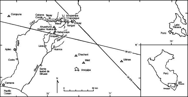 |
Figure 2. Sketch map of SE Perú (box on inset map) showing the locations of Sabancaya and nearby volcanoes (triangles), and towns and rivers in the region. Pilots were warned of eruption cloud hazard along high-altitude routes UB677 and UB679 in the 5 June Notice to Airmen (NOTAM). Low-altitude air routes (W23, W25, and W26) and reporting points (ATIPA, VUGAL, and NEVDO) covered by the 5 June NOTAM are not shown. |
 |
Figure 3. Portion of the Chivay 1:250,000 sheet (SD 19-13, Instituto Geográfico Nacional, Lima, Perú, 1988), showing Sabancaya, Ampato, Hualca-Hualca, and Ahuashune volcanoes, nearby towns, and the upper Colca river valley. Contour interval, 100 m. |
Eruption begins, 29 May. A loud sonic boom on 29 May signalled the onset of periodic explosions at the volcano. From 29 May to 3 June, 2-3 explosions occurred/day with 700-800-m column heights. The eruption plume had a strong sulfur odor. A 1 June press report noted that residents of Maca, 18 km NE of the volcano on the Río Colca, heard underground noises and smelled sulfur (see also 6 June). Two additional seismographs were installed on 3 June and increased seismic monitoring was begun (one seismograph had been installed ~ 10 km SW of the crater in 1989). By 3 June, the plume's height had increased to 1 km and it was blowing SSE (figure 4).
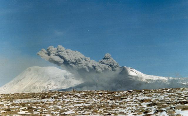 |
Figure 4. Tephra cloud from Sabancaya, viewed from the E on 3 June 1990. Ampato volcano is at left. Photo by Ch. Pattry, courtesy of Alberto Parodi. |
Intensity increases, 4 June. Residents at the base of the volcano reported that explosions had increased to 1 every 20 minutes with a strong sulfur odor and higher noise levels. Ash emission was reported to be continuous, with a column height of 2 km and pulses every few minutes. The plume appeared water-rich, dark gray, and blew NE and ENE, with dense ashfall to 5 km and light ashfall as far as 10 km downwind. Frequent earthquakes were reported.
5 June. The eruption intensity continued to increase, becoming essentially continuous with column heights of 3-6 km. Glowing tephra ejection was reported. The continued ash emission reportedly was seriously affecting grazing land within 10 km of the volcano. Residents in scattered settlements were advised to evacuate at once and remove livestock (llamas and alpacas); many people were reported to have already left. A NOTAM was issued at 1730 stating that routes in the Sabancaya area were affected by the plume, just over 9 km asl (roughly 3 km above the summit).
7 June. The Corporation for Airports and Commercial Aviation requested airlines regularly flying over south Perú to modify routes and issued specific warnings to Perúvian airlines flying to Arequipa. They reported a column to 7 km above the summit. The press reported that the plume headed toward Arequipa and Puno with ash continuing to fall up to 20 km away, destroying pastures and crops, and contaminating the Río Sihuas to the south. Earthquakes were felt at 3-minute intervals in the towns of Chivay (30 km NE of Sabancaya), Maca (18 km NE), Lari (20 km NNE), and Achoma (22 km NE). The press also reported that "crevices with sulfur emanations opened on the ground" in Maca.
8 June. Violent explosions occurred every 5-10 minutes, ejecting pyroclastic material, mainly fine ash, to 1 km height. Ash was reported to cover an area with a radius of 20 km at accumulations up to 1 cm thick. No new lava or juvenile material had been identified. The explosions were accompanied by felt shocks and dull rumbling. The seismic network measured 5-6 microearthquakes/day. Satellite wind data on 11 June indicated that surface winds were from the S, winds at ~ 8 km altitude (372 mbars) were from the NW (298°) at 32-38 m/s (60-70 knots), and winds at >10 km (200 mbars) were from the WNW at 40 m/s (75 knots). As of 17 June, eruptive activity appeared to be continuing to increase.
Geological Summary. Sabancaya, located in the saddle NE of Ampato and SE of Hualca Hualca volcanoes, is the youngest of these volcanic centers and the only one to have erupted in historical time. The oldest of the three, Nevado Hualca Hualca, is of probable late-Pliocene to early Pleistocene age. The name Sabancaya (meaning "tongue of fire" in the Quechua language) first appeared in records in 1595 CE, suggesting activity prior to that date. Holocene activity has consisted of Plinian eruptions followed by emission of voluminous andesitic and dacitic lava flows, which form an extensive apron around the volcano on all sides but the south. Records of observed eruptions date back to 1750 CE.
Information Contacts: A. Parodi, Arequipa; N. Banks, CVO; M. Casaverde, A. Rodriguez, and E. Deza, Instituto Geofísico del Perú, Lima; R. Kosaka, G. Salas Alvarez, and M. Lazo, Univ Nacional de San Agustín, Arequipa; A. Giesecke, CERESIS, Lima; N. Krull, FAA; S. Hamerla, SAB; EFE network, Madrid, Spain; Agence France-Presse; Reuters.