Report on Anatahan (United States) — June 1990
Bulletin of the Global Volcanism Network, vol. 15, no. 6 (June 1990)
Managing Editor: Lindsay McClelland.
Anatahan (United States) No strong local seismicity or significant deformation; crater lake gone
Please cite this report as:
Global Volcanism Program, 1990. Report on Anatahan (United States) (McClelland, L., ed.). Bulletin of the Global Volcanism Network, 15:6. Smithsonian Institution. https://doi.org/10.5479/si.GVP.BGVN199006-284200
Anatahan
United States
16.35°N, 145.67°E; summit elev. 790 m
All times are local (unless otherwise noted)
No eruption has occurred, but island residents have not returned. Geologists visited Anatahan 25-26 June to monitor seismicity, deformation, and morphologic changes since previous fieldwork 19-27 April. No local earthquakes (nearer than 30 km) with magnitudes >2.5 were noted during 26 hours of seismic monitoring. However, strong background noise from ocean surf raised detection thresholds by nearly an order of magnitude from April values. Deformation measurements revealed no significant changes in line length since the April survey, although one line spanning the length of the caldera showed a 12-mm extension.
Since April, large shallow lakes had disappeared from the pit crater in the E part of the main caldera, leaving an area of dark brown unvegetated mud that blended into the area of killed vegetation seen 2 months earlier. Eight pits roughly 10-15 m in diameter were observed in the crater, five containing roiling, sediment-laden, steaming water; all eight were present in April, but five had been within the lake. The most vigorous steaming was occurring from an area of sulfur deposits at the base of the crater wall E of the former lake. Steaming at this feature had been somewhat less vigorous in April.
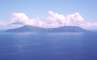
Geological Summary. The elongate, 9-km-long island of Anatahan in the central Mariana Islands consists of a large stratovolcano with a 2.3 x 5 km compound summit caldera. The larger western portion of the caldera is 2.3 x 3 km wide, and its western rim forms the island's high point. Ponded lava flows overlain by pyroclastic deposits fill the floor of the western caldera, whose SW side is cut by a fresh-looking smaller crater. The 2-km-wide eastern portion of the caldera contained a steep-walled inner crater whose floor prior to the 2003 eruption was only 68 m above sea level. A submarine cone, named NE Anatahan, rises to within 460 m of the sea surface on the NE flank, and numerous other submarine vents are found on the NE-to-SE flanks. Sparseness of vegetation on the most recent lava flows had indicated that they were of Holocene age, but the first historical eruption did not occur until May 2003, when a large explosive eruption took place forming a new crater inside the eastern caldera.
Information Contacts: M. Sako and R. Koyanagi, HVO; S. Rowland, Univ of Hawaii.

