Report on Pular (Chile) — June 1990
Bulletin of the Global Volcanism Network, vol. 15, no. 6 (June 1990)
Managing Editor: Lindsay McClelland.
Pular (Chile) Ash emission
Please cite this report as:
Global Volcanism Program, 1990. Report on Pular (Chile) (McClelland, L., ed.). Bulletin of the Global Volcanism Network, 15:6. Smithsonian Institution. https://doi.org/10.5479/si.GVP.BGVN199006-355107
Pular
Chile
24.188°S, 68.054°W; summit elev. 6233 m
All times are local (unless otherwise noted)
Witnesses reported that "on 24 April at 1100 on a clear day with no clouds, a small eruption took place from Pular. It produced an explosion heard at El Laco (a Pacific Mining Company iron mine located 75 km NE; figure 3) and a column of black smoke that lasted just a few minutes above the summit, similar to those observed recently from Lascar." [but see 16:01] Geologists noted that the source of the 24 April eruption remains uncertain. Pular is believed to be Pleistocene in age.
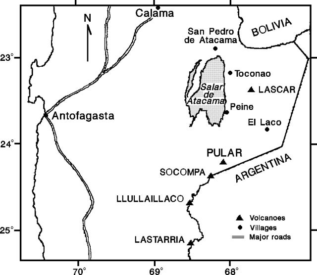 |
Figure 1. Sketch map of a portion of N Chile showing the locations of Pular and nearby volcanoes, and El Laco and other population centers. Courtesy of M. Gardeweg. |
The summit and flanks show signs of deep glacial erosion, including lateral moraines as low as 4,100 m. Pular is the northernmost member of the chain of volcanoes that bears the same name (Cordon Pular). None of the chain has had historic volcanic activity. Cerro Pajonales (24.20°S, 68.10°W), a satellite vent of Pular (5 km SW of the summit; figures 2 and 3), is a lava and dome complex believed to be Quaternary in age. Although evidence of glaciation has been noted on Cerro Pajonales, geologists believed it to be a more likely source of the recent activity.
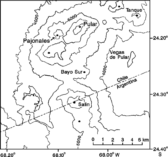 |
Figure 2. Sketch map of Pular from the Sierra Almeida quadrangle (map SG-19-3-4, 1:250,000, Instituto Geográfico Militar, Chile). |
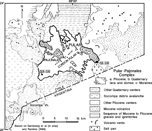 |
Figure 3. Geology map of Pular and surrounding region. Based on Gardeweg and others (in prep.) and Ramirez (1988). |
References. Gardeweg, M., Ramirez, C.F., and Davidson, J., in prep., Hoja Sierra de Almeida, Region de Antofagasta (1:250,000): Carta Geológica de Chile, Servicio Nacional de Geología y Minería.
Ramirez, C.F., 1988, Evidencias de Glaciación en el Macizo de los Volcanes Pular y Pajonales, Región de Antofagasta: Actas V Congr. Geol. Chileno, Tomo II, p. D143-D157.
Geological Summary. Cerro Pular on the NE end and Cerro Pajonales on the SW form a 12-km-long volcanic ridge NE of Socompa volcano that is mostly pre-Holocene, but may have experienced some more recent activity. The chain lies NW of the Salar de Pular, about 15 km W of the Argentinian border. Extensive andesitic lava flows reach the lower flanks of the volcanoes, and about 10 craters are present. A major satellite vent W of the ridge appears to be the youngest feature of the volcanic complex. An uncertain small explosive eruption was reported in 1990, but the vent location was not known.
Information Contacts: M. Gardeweg, SERNAGEOMIN, Santiago; Vinicio Travisany, CMP (Pacific Mining Company).