Report on Unzendake (Japan) — July 1990

Bulletin of the Global Volcanism Network, vol. 15, no. 7 (July 1990)
Managing Editor: Lindsay McClelland.
Unzendake (Japan) 397 events recorded during two-day earthquake swarm; weak volcanic tremor episodes
Please cite this report as:
Global Volcanism Program, 1990. Report on Unzendake (Japan) (McClelland, L., ed.). Bulletin of the Global Volcanism Network, 15:7. Smithsonian Institution. https://doi.org/10.5479/si.GVP.BGVN199007-282100
Unzendake
Japan
32.761°N, 130.299°E; summit elev. 1483 m
All times are local (unless otherwise noted)
A M 3.9 earthquake struck 3 km W of Hugendake, the summit peak of Unzen, on 7 July. An earthquake swarm began on 24 July and continued the next day. During the two-day swarm, 397 events were recorded and 26 shocks were felt [at UWS]. The strongest swarm event, M 2.3, occurred at 2206 on 24 July. The monthly number of recorded earthquakes was 922 (figure 3), 34 of which were felt. Most of the earthquakes were centered 5-10 km W of the summit.
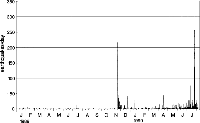 |
Figure 3. Daily number of earthquakes at Unzen, January 1989-5 August 1990. Courtesy of JMA. |
Weak volcanic tremor episodes were recorded on 4, 5, and 30 July, and 1, 5, and 6 August. Each episode lasted between 20 and 100 seconds. [No volcanic tremor had been recorded since the beginning of seismic observation in 1966.]
Further Reference. Shimizu, H., and Matsuo, N., 1988, Seismic activity and tectonic stress in the Unzen volcanic region: Proceedings, Kagoshima International Conference on Volcanoes, p. 339-341.
Geological Summary. The massive Unzendake volcanic complex comprises much of the Shimabara Peninsula east of the city of Nagasaki. An E-W graben, 30-40 km long, extends across the peninsula. Three large stratovolcanoes with complex structures, Kinugasa on the north, Fugen-dake at the east-center, and Kusenbu on the south, form topographic highs on the broad peninsula. Fugendake and Mayuyama volcanoes in the east-central portion of the andesitic-to-dacitic volcanic complex have been active during the Holocene. The Mayuyama lava dome complex, located along the eastern coast west of Shimabara City, formed about 4000 years ago and was the source of a devastating 1792 CE debris avalanche and tsunami. Historical eruptive activity has been restricted to the summit and flanks of Fugendake. The latest activity during 1990-95 formed a lava dome at the summit, accompanied by pyroclastic flows that caused fatalities and damaged populated areas near Shimabara City.
Information Contacts: JMA.