Report on Kusatsu-Shiranesan (Japan) — October 1990
Bulletin of the Global Volcanism Network, vol. 15, no. 10 (October 1990)
Managing Editor: Lindsay McClelland.
Kusatsu-Shiranesan (Japan) Continued high seismicity but no surface changes
Please cite this report as:
Global Volcanism Program, 1990. Report on Kusatsu-Shiranesan (Japan) (McClelland, L., ed.). Bulletin of the Global Volcanism Network, 15:10. Smithsonian Institution. https://doi.org/10.5479/si.GVP.BGVN199010-283120
Kusatsu-Shiranesan
Japan
36.618°N, 138.528°E; summit elev. 2165 m
All times are local (unless otherwise noted)
Seismicity has remained at high levels... (figure 4). During October, 213 earthquakes (up from 184 in September) and 29 tremor episodes... were recorded. Tremor amplitudes were similar to previous months. Earthquakes were centered 1 km E of... Yugama Crater. Seismicity remained similar as of 14 November. No changes in surface activity were observed.
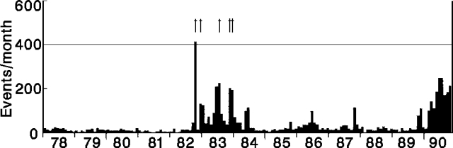 |
Figure 4. Monthly number of earthquakes at Kusatsu-Shirane, January 1978-October 1990. Arrows at top of figure mark eruptions. Courtesy of JMA. |
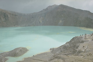
Geological Summary. The Kusatsu-Shiranesan complex, located immediately north of Asama volcano, consists of a series of overlapping pyroclastic cones and three crater lakes. The andesitic-to-dacitic volcano was formed in three eruptive stages beginning in the early to mid-Pleistocene. The Pleistocene Oshi pyroclastic flow produced extensive welded tuffs and non-welded pumice that covers much of the E, S, and SW flanks. The latest eruptive stage began about 14,000 years ago. Historical eruptions have consisted of phreatic explosions from the acidic crater lakes or their margins. Fumaroles and hot springs that dot the flanks have strongly acidified many rivers draining from the volcano. The crater was the site of active sulfur mining for many years during the 19th and 20th centuries.
Information Contacts: JMA.