Report on Eldey (Iceland) — October 1990

Bulletin of the Global Volcanism Network, vol. 15, no. 10 (October 1990)
Managing Editor: Lindsay McClelland.
Eldey (Iceland) Strong seismicity; turbid water and hydrothermal area but no new lava detected
Please cite this report as:
Global Volcanism Program, 1990. Report on Eldey (Iceland) (McClelland, L., ed.). Bulletin of the Global Volcanism Network, 15:10. Smithsonian Institution. https://doi.org/10.5479/si.GVP.BGVN199010-371022
Eldey
Iceland
63.733°N, 23°W; summit elev. 70 m
All times are local (unless otherwise noted)
The following is a report from Páll Einarsson. "An intense earthquake swarm started on the N part of the Reykjanes Ridge on 30 October (figure 3). The first event recorded by seismographs in Iceland occurred at 1021 and had a magnitude of 3.5. Smaller events occurred at 1052 and 1152. The epicenters cannot be located accurately, but appear to be near 63°N, or ~180 km SW of Reykjavík. At 1229, activity in this area increased dramatically, and for the next 19 hours hundreds of earthquakes were recorded. The largest events approached M 5 and at least 14 were of M 4 or larger. For large parts of this time, the seismographs showed continuous motion due to the dense sequence of small and large earthquakes. However, motion resembling volcanic tremor could not be identified.
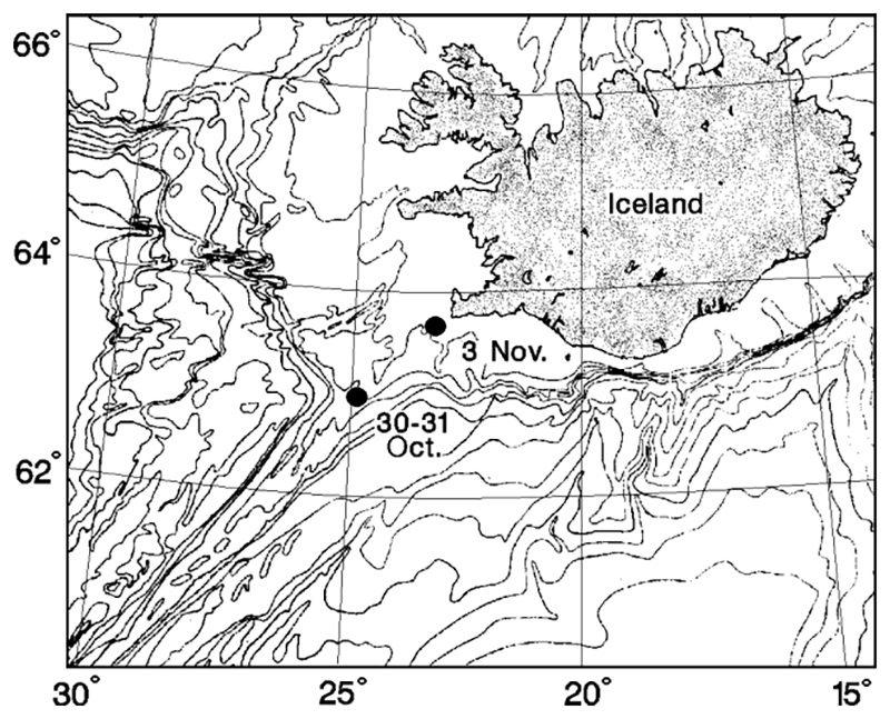 |
Figure 3. Sketch map showing the approximate location of the earthquake swarms near 63°N and 63.7°N on the Reykjanes Ridge. After Perry and others (1980). |
"The intense activity came to a rather abrupt halt at about 0800 on 31 October, but activity at a lower level continued, gradually diminishing. A temporary increase occurred 5-6 November (figure 4).
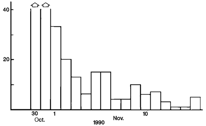 |
Figure 4. Number of earthquakes from the Reykjanes Ridge swarm area recorded daily at the Háhryggur seismic station in SW Iceland. Detection threshold of the station for this area is near magnitude 2.5. Courtesy of P. Einarsson. |
"A second swarm started 3 November closer to Iceland, near 63.7°N. It began at 1426 with an event of M 3.8. Thirty events were recorded in the area that day, and five events the following day. This swarm was small and short-lived, and probably unrelated to the first one.
"The question of whether or not the swarm at 63°N is related to intrusive or extrusive activity at the sea floor cannot be answered from the available seismic data. Earthquake swarms are common on the Reykjanes Ridge and its landward continuation on the Reykjanes Peninsula. None of the recent swarms on the peninsula have been accompanied by eruptive activity, and they do not resemble the seismic swarms that accompany magmatic intrusions in the Krafla area along the rift zone in NE Iceland. Intrusion tremor, commonly observed at Krafla, has not been recorded during the swarms on the Reykjanes Peninsula despite a relatively dense seismograph network there.
"The current swarm at 63°N is unusual in both intensity and duration. The large distance to the nearest seismograph (roughly 150 km) means that intrusion and extrusion tremor could have occurred without being observed. Some characteristics of the swarm - for example the slow beginning, the high density of events at its culmination, and the abrupt end - in some respects resemble those of some of the Krafla eruptive events. If an analogy is drawn, one could speculate that the intense part of the swarm accompanied an intrusion of magma and that a dyke propagated for 19 hours. If an eruption occurred, it most likely began at about 0800 on 31 October when the seismic activity suddenly dropped to a lower level. Eruptive activity may have ended on 5 November, when there was a temporary increase in earthquakes."
A U.S. Navy P3 aircraft overflew the swarm area on 2 November between 1000 and 1400. Five sonobuoys were deployed; the central sonobuoy (at 63°15'40"N, 24°11'52") detected 50 Hz noise at 97 dB; sound intensity at four others (~ 9 km N, S, E, and W) was about 85 dB.
The following is from Jón Olafsson. "In response to the earthquake swarm on the Reykjanes Ridge, an international team assembled in Reykjavík on 2 November, sailing at midnight on the RV Bjarni Saemundsson of Iceland's Marine Research Institute.
"Investigations were concentrated on the area of the ridge crest between 62.9°N and 63.3°N, where the water depth ranged from 100 to 500 m. The ship is equipped with echosounders, sonar, and a CTD (Conductivity-Temperature-Depth) + light transmissometer with a rosette for water column sampling. On board were sonobuoys (provided by the U.S. Navy), equipment for analysis of dissolved silica, and a bottom dredge. Signs of possible eruptive activity were sought by deployment of sonobuoys, and water sampling on sections along and to the sides of the ridge crest. No signs could be detected of explosive activity of the type that created Surtsey in 1963, which would have given rise to extensive silica anomalies. However, the water above a segment of the ridge centered at 63.1°N showed some anomalous properties, particularly decreased light transmissivity and water column stability. A hydrothermal region was discovered near the summit of a seamount in this region, but has most likely been there beforehand, judging from previous information from fishermen. On the afternoon of 5 November, two nearby earthquake shocks were felt on the ship. Reports of earthquakes also came from deep-sea trawlers in this region, confirming that the research effort was in the region of seismic activity. Twelve dredge hauls brought up some fresh basalts but none were newly erupted.
"The ship returned to Reykjavík on 6 November with water samples for analysis of helium isotopes, manganese, methane, and hydrogen. Processing of these samples and the instrument records will be conducted in the UK, Iceland, and USA."
Locations of four of the largest earthquakes in the swarm were determined at the U.S. National Earthquake Information Center on 4 November (table 2). Arrival time values were obtained from the NEIC database, and from two seismic stations in Iceland (~150 and 250 km from the epicentral area), reported by Páll Einarsson. The following is from Eric Bergman.
Table 2. Relocations of four large earthquakes from the Reykjanes Ridge swarm, 30-31 October 1990. Courtesy of Eric Bergman.
| Date | Time | Latitude | Longitude | Magnitude (mb) |
| 30 Oct 1990 | 1307 | 62.95 ± 0.08°N | 24.60 ± 0.07°W | 4.7 |
| 30 Oct 1990 | 1403 | 63.06 ± 0.06°N | 24.64 ± 0.07°W | 5.0 |
| 30 Oct 1990 | 1915 | 63.11 ± 0.08°N | 24.75 ± 0.10°W | 4.7 |
| 31 Oct 1990 | 0658 | 63.17 ± 0.06°N | 24.64 ± 0.07°W | 4.6 |
"The swarm events were relocated as part of a multiple-event relocation analysis for earthquakes on the Reykjanes Ridge between 62.5°N and 63.5°N. In all, 30 well-recorded earthquakes were relocated, using the hypocentroidal decomposition technique. Locations were estimated using the 1968 Herrin tables for P-wave travel times, except for the two Icelandic stations. Because the Herrin tables assume a thick continental crust, the theoretical travel times are longer than the true travel times for these phases, which propagate predominantly as refracted waves along the oceanic Moho with a velocity of around 8 km/s. Theoretical travel times for the two Icelandic stations were calculated by dividing the epicentral distance by 8.0 km/s. This admittedly crude estimate is a substantial improvement over the standard tables and is in good agreement with other data. No station corrections were used in the relocation. All focal depths were fixed at 10 km, consistent with many studies of the depth distribution of mid-ocean ridge seismicity. Further work is needed to refine this type of analysis, and it should be recognized that the locations reported here are to some extent biased by these assumptions. The results of the analysis will also change as more arrival data accumulate."
Reference. Perry, R.K., Fleming, H.S., Cherkis, N.Z., Feden, R.H., and Vogt, P.R., 1980, Bathymetry of the Norwegian-Greenland and western Barents Seas: U.S. Naval Research Laboratory-Acoustics Division, map and chart series MC-21
Geological Summary. The Eldey volcanic system is located on the northernmost part of the Reykjanes Ridge and is submarine with the exception of Eldey Island and the skerries (small rocky islands) Eldeyjardrangur, Geirfugladrangur, and Geirfuglasker. Maximum water depth within the system is about 250 m. Characteristic activity consists of explosive submarine basaltic eruptions. Six small eruptions have been located within this system during the last 1,100 years, the last occurring in 1926 CE. Bulletin reports that are included here cover a larger area of the Reykjanes Ridge south of Iceland without a clear source or enough evidence for a separate volcano entry.
Information Contacts: P. Einarsson, Univ of Iceland; J. Olafsson, Marine Research Institute; E. Bergman, NEIC; P. Vogt, Naval Research Laboratory; T. Stroh, Univ of Washington. Scientific team on the RV Bjarni Saemundsson: Jón Olafsson, Icelandic Marine Research Institute (leader); Johnson R. Cann, Univ of Leeds (deputy leader); Kjartan Thors, S. Kristmansson, and Jón Benjaminsson, Icelandic Marine Research Institute; David Francis, Univ of Leeds; Cherry Walker, Univ of Durham; and Marie de Angelis, State Univ of New York, Stony Brook. Sponsoring Institutions: Icelandic Marine Research Institute; Natural Environmental Research Council, UK; and RIDGE Office, National Science Foundation, USA.