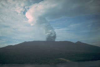
Report on Karkar (Papua New Guinea) — December 1990
Bulletin of the Global Volcanism Network, vol. 15, no. 12 (December 1990)
Managing Editor: Lindsay McClelland.
Karkar (Papua New Guinea) Weak fumarolic activity; deflation of inner caldera floor
Please cite this report as:
Global Volcanism Program, 1990. Report on Karkar (Papua New Guinea) (McClelland, L., ed.). Bulletin of the Global Volcanism Network, 15:12. Smithsonian Institution. https://doi.org/10.5479/si.GVP.BGVN199012-251030
Karkar
Papua New Guinea
4.647°S, 145.976°E; summit elev. 1839 m
All times are local (unless otherwise noted)
"An inspection and ground deformation measurement were carried out between 2 and 6 November. Weakly active fumaroles were noted at the summit and on the SW flank of Bagiai cone, and at the top of the 1979 crater's W wall. Temperatures at Bagiai's summit ranged between 64.8 and 79.7°C. When last measured (July 1989) the temperature range was 74-84°C. Considerable vegetation regrowth was noted on Bagiai and on the caldera floor and walls.
"The results of dry tilt measurements, compared with results from July 1989, suggest deflation (9-30 µrad) of the floor of the inner caldera. The results from stations on the upper S flank are inconsistent, with one station showing a small component of deflation and the other station showing 20 µrad of inflation. The station on the lower SW flank showed negligible change while the station at the NW coast showed a moderate (but somewhat doubtful) component of deflation. Levelling measurements showed a continuation of progressive deflation of the inner caldera floor. EDM results also indicated deflation of the summit area."
Geological Summary. Karkar is a 19 x 25 km forest-covered island that is truncated by two nested summit calderas. The 5.5 km outer caldera was formed during one or more eruptions, the last of which occurred 9,000 years ago. The steep-walled 300-m-deep, 3.2 km diameter, inner caldera was formed sometime between 1,500 and 800 years ago. Cones are present on the N and S flanks of this basaltic-to-andesitic volcano; a linear array of small cones extends from the northern rim of the outer caldera nearly to the coast. Recorded eruptions date back to 1643 from Bagiai, a pyroclastic cone constructed within the inner caldera, the floor of which is covered by young, mostly unvegetated andesitic lava flows.
Information Contacts: B. Talai, RVO.

