Report on Almolonga (Guatemala) — December 1990
Bulletin of the Global Volcanism Network, vol. 15, no. 12 (December 1990)
Managing Editor: Lindsay McClelland.
Almolonga (Guatemala) Landslide in geothermal field; 23 people reported dead
Please cite this report as:
Global Volcanism Program, 1990. Report on Almolonga (Guatemala) (McClelland, L., ed.). Bulletin of the Global Volcanism Network, 15:12. Smithsonian Institution. https://doi.org/10.5479/si.GVP.BGVN199012-342040
Almolonga
Guatemala
14.797°N, 91.519°W; summit elev. 3173 m
All times are local (unless otherwise noted)
International press reports stated that a well blowout in the Zunil geothermal field triggered a landslide that killed [23] people. Later investigation determined that the landslide [was more likely caused by failure of the steep slopes above the well than by a "blowout"]. The following report is intended to clarify events and document the deposits.
A landslide occurred at approximately 2230 on 5 January at Zunil geothermal field (figure 19) (2.5 km WSW of Zunil, on the E flank of Santa María volcano; Santiaguito is on the SW flank of Santa María), damaging either the wellhead or the surface casing (or both) of well ZCQ-4. The landslide scarp was above the well pad, and it was unclear if the damaged geothermal well played a role in causing the landslide. The landslide lobes flowed ESE about 1 km from above the well site, destroying . . . 6-8 houses on the level terrace area below, and blocking the road between Quetzaltenango and Retalhuleu. Seventeen bodies had been recovered by 10 January, but other reports indicated that 33 people had been killed. Rescue workers continued to search for buried survivors on 7 January. The site of a proposed 15-megawatt geothermal power plant and an older well (ZCQ-1) were covered with slide debris. Well ZCQ-4 was blowing uncontrolled, and the Instituto Nacional de Electrificación (INDE) was [exploring ways to shut-in the well, which was buried by slide debris]. Another well, ZD-1, was being drilled when the landslide occurred, and the crew was evacuated safely.
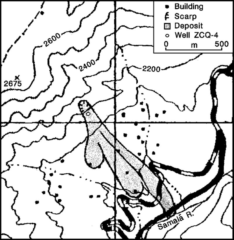 |
Figure 1. Sketch map showing well ZCQ-4 in the Zunil geothermal field and deposits of the 5 January landslide. Contour interval, 100 m. From the Colomba and Santa Catarina Ixtahuacán quadrangles (nos. 1860 II and 1960 III). |
The landslide was composed of four overlapping lobes, the lowest of which was mostly kaolinite and fine-grained altered volcanic materials; a large area of intensely argillically altered rocks had existed above the wellsite before geothermal development began in the 1970's. The three subsequent landslide lobes were smaller, and appeared to be wetter but less highly fluidized than the first. The first deposit was sufficiently fluidized that people sank to 10 cm depth when walking across its surface. While the long axes of the largest boulders transported by the landslide were 2-4.5 m, boulders had average diameters of 0.4 m in the first flow, and 0.58 m in the second flow. The first flow had a less-prominent levee (about 1 m high) than the second (2-3 m high). In many places, deposit surfaces and the ground nearby were partially covered by fine material that appeared to have been laterally "sprayed" over the surfaces, apparently by the landslide itself.
The landslide covered an area [>800 m long and 200-300 m wide, with a combined thickness of 3-10 m]. [Calculations by Flynn and others (1991) indicated a slide volume of about 800,000 m3.] The vertical distance between the top of the scarp, 80 m high and 60 m wide, and the distal toe of the landslide was about 250 m. [Topographic releif in the vicinity of the slide is extreme; measured slope angles range from 30 to 50°.] On 7 January, an additional landslide was caused by the collapse of a 50-m-tall andesitic lava column that detached from the landslide scarp.
A cone of loose material that surrounds the well appeared to have been constructed when landslide debris around the well was thrown out by escaping steam. The cone was about 15 m across, and 10 m high, with steam emerging through a 5-m-diameter crater at the top, carrying particulate matter to 10-20 m height on 7 January. An earlier such cone collapsed, forming one of the upper 3 landslide lobes. Andrés Caicedo reported that the steam discharge was considerably less than when the well was previously flow-tested, possibly suggesting that the wellhead was damaged but intact.
Reports vary on the presence of precursor activity. [There was no record of rain before or during the slide.] Luis Mérida reported that new ground cracks appeared near ZCQ-4 about 1 week prior to the landslide and Mérida recommended evacuating the area. However, no earthquakes were reported.
ZCQ-4 was drilled in 1981 to 1,026 m total depth. . . . The maximum measured reservoir temperature was [260°C].
Further Reference. Adams, M.C., Mink, L., Moore, J., White, L., and Caicedo Anchissi, A., 1990, Geochemistry and hydrology of the Zunil Geothermal System, Guatemala: Geothermal Resources Council Transactions, v. 14, Part II, p. 837-844.
Flynn, T., Goff, F., and others, 1991, [title unknown]: Geothermal Resources Council Transactions, v. 15, p. 425-433.
Schaefer, S., and Williams, S., 1991, [title unknown]: Geotimes, May 1991, p. 20-22.
Geological Summary. Volcán de Almolonga is an andesitic stratovolcano with a 3.3-km-wide late-Pleistocene central caldera that is located along the Zunil fault zone. The caldera is surrounded by a ring-dike configuration of dacitic and rhyolitic lava domes. The youngest and only historically active dome complex is Cerro Quemado (whose name means Burned Peak), located immediately south of Guatemala's second largest city, Quezaltenango. About 1200 radiocarbon years ago, part of the andesitic-to-dacitic Cerro Quemado dome collapsed, producing a debris avalanche and an associated lateral explosion that swept across the valley to the west as far as the flanks of Siete Orejas volcano. The latest eruption in 1818 produced a blocky 2.5-km-long lava flow. Hot springs are located on the northern and eastern flanks of Cerro Quemado, and the Zuníl geothermal field, the site of a geothermal exploration project, lies on the SE flank of Cerro Quemado.
Information Contacts: S. Williams, M. Calvache, S. Schaefer, T. Ross, and other field trip participants, Louisiana State Univ, USA; Andrés Caicedo, INDE, Guatemala City, Guatemala; Luis Mérida, Cordon y Mérida, Guatemala City, Guatemala; David Sussman, UNOCAL Geothermal Division, P.O. Box 6854, Santa Rosa, CA 95406 USA; Marshall Reed, U.S. Dept of Energy, USA; Otoniel Matías, INSIVUMEH. [Corrections and additions by David Sussman.]